Week 11: Arequipa, Colca Canyon, Nasca & Lima

peruweek11

AREQUIPA

The White City of Peru, apparently named not only for the color of the buildings, but also because it was the city with the highest number of European immigrants. My two favorite parts of Arequipa were the queso helado and the incredible sunsets in the main square. Queso helado isn’t actually frozen cheese, but a delicious and yummy local ice cream.

arequipa.jpg

sunset over the cathedral, queso helado, sunset over the Plaza de Armas

Arequipa is known for the Santa Catalina Monastery, which is basically a small city within the city. Wealthy Spanish sent their daughters to live there until they died, paying a monthly sum for their daily upkeep the rest of their lives. Each nun basically had their own apartment within the complex, but weren’t allowed contact with the outside world except in one small room.

arequipa1.jpg

laundromats for the nuns, beautiful fountain, walkway of a plaza

COLCA CANYON

On the way to the canyon, there is a famous stopping point known as the Cruz del Condor where there are almost always Andean condors flying in the morning hours. This point is at the cross-section of winds and the condors ride them all morning scavenging for food. We saw quite a few before venturing on to start our trip into one of the deepest canyons in the world. This overnight hike into Colca Canyon involved a really, really long and really, really hot walk down into the canyon and a really, really steep hike out in the morning starting while there were still stars out.

colca.jpg

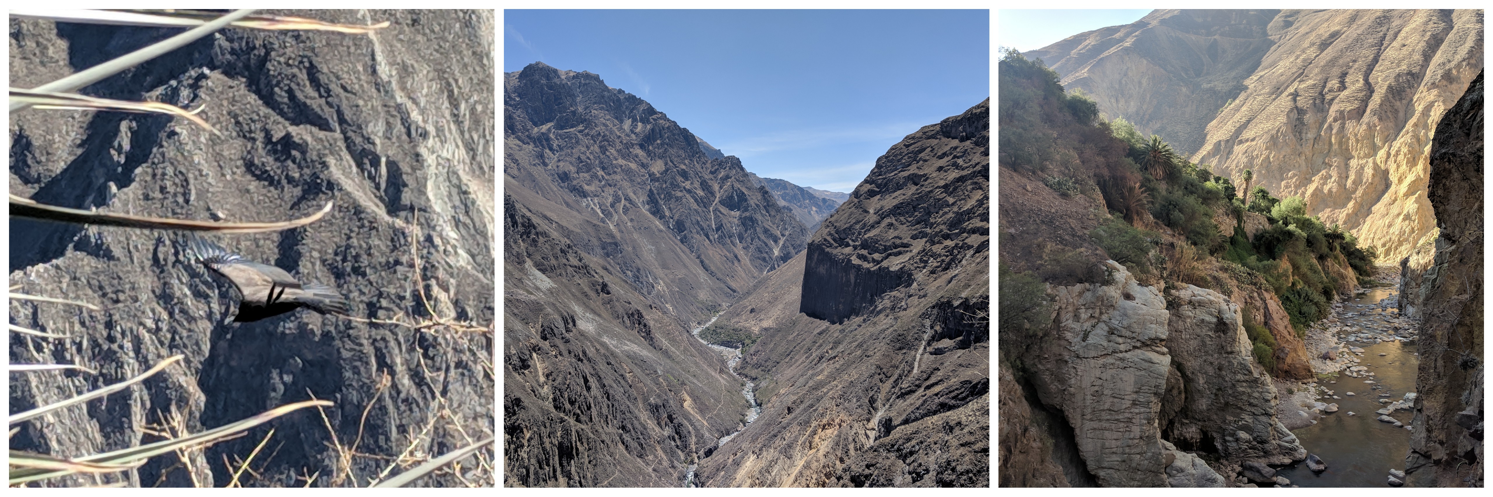
Andean condor, view from the start of the hike, view from the end of the hike

colca1.jpg

oasis where we spent the night, early morning hiking, hexagonal basalt columns

One thing I failed to capture on camera (sorry!) was my first introduction to cochineal bugs living on prickly pear cactus. Squishing them exudes a red dye that can be used to decorate skin and (if enough are harvested) color clothing. I’d seen these dried bugs in markets, but never actually seen them alive on cacti.

NASCA

The only real way to see the Nasca Lines is to get up in a plane, so I paid the money and hopped aboard a little prop plane to see these beautiful creations. They were made by digging small trenches that removed the top layer of gravel and exposed the subsoil underneath which is lighter in color. Their cultural importance is still up for speculation and there are way more designs than the ones here.

nasca.jpg

top (l to r): tree, monkey, spider
bottom (l to r): condor, hands, hummingbird

LIMA

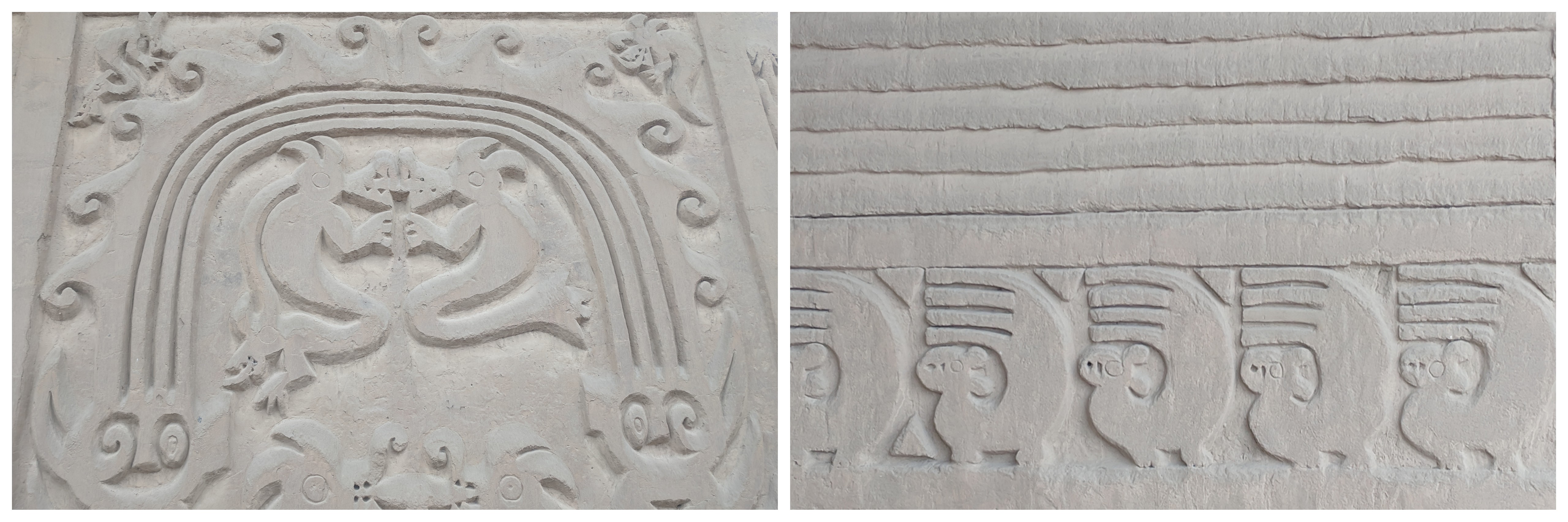
I don’t usually take photos of museum pieces, but the Museo Larco in Lima is a pretty exceptional museum. I find the patterns on Nasca (also written Nazca) pottery to be stunning, so I thought I’d share a few of the more spectacular pieces. This type of art was actually the inspiration for many modern and cubist artists of the 20th century.

lima.jpg

Nasca pottery, top of a Nazca drum, close-up of Nazca pottery

Other highlights included skulls that were opened up in Inca times. This brain surgery would have been performed to help hematomas or remove parts of the skull that had been fractured in war. The skull on the left doesn’t show any bone regrowth so the person probably died from the effort. However, the one on the right shows lots of growth so that person lived quite a while after the surgery was performed.

Also on display were sculptures depicting cultural scenes, textiles covered in feathers, and rooms full of jewelry. Many rulers of early Peruvians wore giant earplugs as a symbol of status. Some of these are 3-4″ across, so you can imagine how large their earlobes had to be stretched to accommodate these works of art.

lima1.jpg

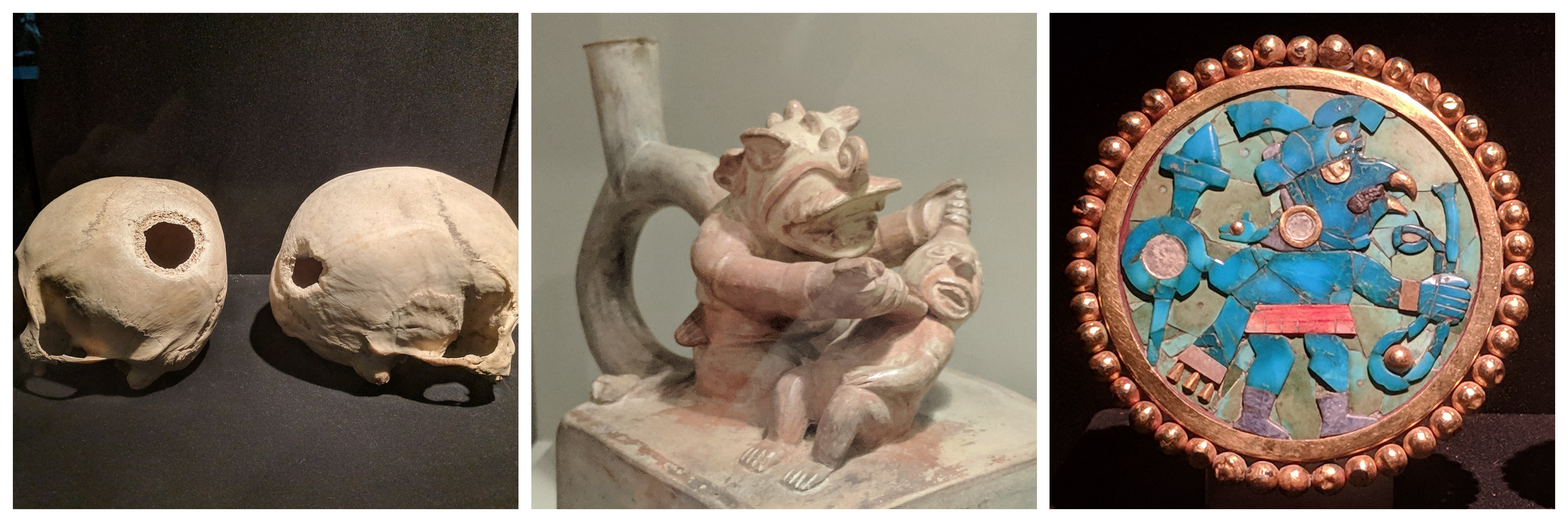
skulls after surgery, decapitation ceramic, mosaic Moche ear plug

WANT A POSTCARD?

This offer is still valid. 🙂If you want a postcard from overseas, fill out this postcard form! At some point this school year, I will send you a postcard from somewhere outside the United States.

Week 10: Puno, Inca Trail & Cusco

peruweek10

PUNO

An early morning boat ride whisked me out to the floating islands of the Uros on the Peruvian side of Lake Titicaca. This is a group of people who were sick of fighting with other people on the mainland, so they made their permanent home in the middle of the lake on artificial islands they made out of plants. The woman in the photo is demonstrating how this works: a large layer of floating roots tied together, followed by reeds, then houses go on top. The plants are constantly decomposing, so there is constant work to maintain and upkeep the islands and structures.

puno.jpg

floating reed islands (with solar panels), explaining how the reed islands are built, incredible reed boats

INCA TRAIL

Day 1: We left before the sun rose and the first day was a relatively easy wander along the Willkamayu River (also known as the Urubamba). To the Incas, this river was the earthly version of the Milky Way and reflected the duality between the heavens and the land. After passing the agricultural city of Patallacata, we camped in the middle of some gorgeous mountains.

incaday1.jpg

start of the trail over the Willkamayu River, Patallacta, view from evening campsite

Day 2: This was a shock to the system with a never ending set of stairs towards Dead Woman’s Pass, named because of the shape of the mountain. I’d been at pretty high elevation for the last two weeks, but I was still moving slowly, especially towards the top. There’s a lot of ups and a lot of downs, but the scenery and company was fantastic.

incaday21.jpg

hiking through cloud forests with awesome people

incaday2.jpg

on the way to the pass, celebrating making it to the top, the view down from the pass

Day 3: After waking up at the break of dawn, we headed out for a full day of ruins. In the morning we stopped at the beautiful temple of Sayamarka.

incaday3

cloudy view from Sayamarka window, chillin’ in the old temple, flowers growing from a crack

PANO_20181112_094313.vr.jpg

view of Sayamarka

Although the rain picked up after lunch, we were able to visit more Inca sights after lunch. Their splendor and size got grander as we got closer to Machu Picchu. The current theory is that Machu Picchu was a country estate designed for the Inca ruler Pachacuti. When he left Cusco, he would take up residence in this citadel. As his entourage moved along the Inca Trail, there would have been teenage sacrifices (some self-chosen and some chosen by parents) and celebrations in his honor. For this reason, there is a sacrifice table at one of these temples and the blood would run from this spot higher up to the temples at the bottom of the mountain through a series of canals.

incaday31

Phuyupatamarka, the group in our colorful rain gear, Intipata

Our guide gave us a special evening tour of the beautiful ruins of Wiñay Wayna. Inside of this temple there would have been an Inca mummy that continued to dispense advice and wisdom even after death.

incaday32

view of Wiñay Wayna, after dark special effects

Day 4: One last ridiculously early morning and we were finally on our way to Machu Picchu.  The clouds were out as soon as we started walking, so there were no beautiful views. The spectacular tourist shot that everyone takes was a giant cloud when we went by. After dropping our bags off, we went off on a tour of the ruins. Machu Picchu has a little bit of everything: deluxe bedrooms, temples, vast terraced agricultural lands, educational spaces, intensive plumbing, and astronomical observatories. I had gotten a ticket to climb Huayna Picchu, but after 4 days of non-stop hiking, I only made it up the slightly smaller hill nearby to capture a photo of its incredible beauty.

incaday4

Sun Temple, Room of Three Windows, Intihuatuana (used for observing astronomical events)

PANO_20181113_085949.vr.jpg

Machu Picchu in the clouds

incaday41

Machu Picchu, me and our guide, view from nearby hill

By the way, if you’re looking for a company to hike the Inca Trail with I highly reccommend Evolution Treks Peru. They’ve got women porters, excellent guides, and treat their workers extremely well.

CUSCO

I ate a huge meal of Chifa (Peruvian-Chinese food served with limes and ají) and promptly fell asleep at 8:00pm. When I woke up, my calves were a tingling mess of soreness, but I endeavored to get moving regardless. I wandered through some museums and markets, but my highlight was going to the family-run Cusco Planetarium. I learned all about the black llama that can be seen in the Milky Way. Its eye is one of the pointer stars to the Southern Cross. In addition, I found out that Incas most likely used the Pleiades to determine whether or not they were going to have an El Niño year. When they were bright and clear they would have a regular year, but when they were blurry and faded, they would have an El Niño year. This has do with the arrangements of winds, weather, cloud cover, and geography (scientific article in Nature).

IMG_20181115_111851

Milky Way dark constellations (from display at Qori’kancha)

I also spent a day exploring some ruins near to Cusco known as Inkilltambo, the Garden Hostel. There were beautiful terraces for agriculture, a jail, and a place for storing grain. The Inca empire mastered agriculture in a very difficult and mountainous terrain. Even the Spanish recorded that no one was hungry in the Inca Empire. (This can probably be attributed to the m’ita system of forced labor, which has some elements of public service and some elements of straight-up oppression).

cusco.jpg

Inkilltambo: sacred rocks, grain storage, reconstructed housing

WANT A POSTCARD?

This offer is still valid. 🙂 If you want a postcard from overseas, fill out this postcard form! At some point this school year, I will send you a postcard from somewhere outside the United States. I can’t guarantee it will be delivered, but I will send it. The first set of postcards has already departed Peru!

Week 7: Trujillo & Lima

peruweek7

ECUADOR-PERU BORDER

Traveling south from Ecuador, I took a couple of buses for some long travel (14 hour-ish) into Peru. The border between Ecuador and Peru is full of Venezuelan refugees sleeping and waiting to be let in. UNHCR has water and medical stations set up to help, but I’ve never seen a border crossing like it in my entire life. The economic meltdown has led to millions of Venezuelans leaving their country and flooding into neighboring regions. Read more about it in this BBC article. Although many Latin American countries have been very receptive, the flow of refugees hasn’t ceased, which is leading to backlogs and countries starting to close their borders and the situation I witnessed.

TRUJILLO

Trujillo is known for having some of the most amazing Pre-Columbian ruins in South America, which seemed like a great reason to stop. I set out on a daylong tour to explore and our first stops were to see building constructed by the Chimú empire around 1300 AD. They are called huacas, which translates to tombs, but seemed to be used more for ritual sacrifice and other religious purposes. Their empire used to span a huge part of present-day Trujillo right up to the ocean. Although the area is quite arid now, presumably back in the day it was more lush because sea otters and squirrels are found engraved in the walls.

trujillo2.jpg

sea otter engravings at La Huaca Arco Iris and squirrel engravings at La Huaca Esmeralda

The next stop was Hacienda Chan Chan, a sprawling structure in which some parts have been extensively rebuilt. Before these buildings were found, they were protected by the sand and mud that had accumulated around them. Being exposed to the weather has worn down many of the engravings and there is much work that has been done to try and protect what is currently open to the air.

trujillo.jpg

pelican engraving, view of remodeled section of Hacienda Chan Chan, geometric pelican engraving

Next up was La Huaca de la Luna, and a trip back even further in time to learn about the Moche. This sight has one of the most extensive museums I’ve seen so far with elaborate explanations of cultural rituals. This place was built over many centuries, ending around 600 AD. Many ceramics and carved wall paintings have survived and so much more is known about these people, including their practice of ritual sacrifice and that those practices changed based on whether or not they were experiencing an El Niño. Just to emphasize, the Moche knew about El Niño over 1500 years ago.

trujillo1.jpg

engravings of spider crab, head deity Aiapaec the Decapitator, octopus legs

IMG_20181016_164908.jpg

incredible painted engraved door

LIMA

I had a 12 hour stopover in Lima and I really did see many things: catacombs under the Monastery of San Francisco, the coffin containing the bones of conquistador Francisco Pizarro (a.k.a. the murderer of the Incan emperor Atahualpa) inside the Cathedral, and an incredible art museum (I’m in love with the Peruvian graphic designer Elena Izcue who took her inspiration from Nazca pottery). However, perhaps because I was still sleepy or because photos weren’t allowed in some of these spots, I have no photos to share except for a protest I passed which I believe had something to do with the Fujimoris (the former president’s daughter had recently been arrested for money laundering). Nevertheless, I thought the imagery of this bird overlooking the police officers was both creative and symbolic.

IMG_20181017_173502