Chile: Total Solar Eclipse & Rapa Nui

Now that I’m starting teaching again in August, I’ve been debating whether or not to continue blogging. I decided the wanderlust isn’t going away, so I’m going to keep writing and sharing for now. 🙂

La Serena, Chile

I was just in this beautiful country in December, so it seemed a little crazy to go back, but there was a total solar eclipse! I had some frequent flier miles to burn (thanks to some credit card scheming) and some good friends to visit again. After two long flights, a bus ride and a five hour car ride, we arrived in our beautiful condo for the weekend that looked out over the Pacific Ocean. Cata (who you may remember from my trip to Valparaiso) introduced me to brazo de reina, which is basically really thin cake covered in dulce de leche and then rolled up.

chile2

beautiful sunset, me and Cata, brazo de reina

Total solar eclipses are pretty rare. I traveled to Shanghai in 2009 and Kansas City, Missouri in 2017 and both of those eclipses happened to be clouded out. Fortunately, the weather cooperated and I was finally able to see one. It’s a truly spectacular sight and it’s hard for me to put into words my excitement at witnessing such a beautiful phenomenon after so many attempts. The next one in the United States is April 8, 2024. Put it on your calendar now so you can make plans.

chile1

total solar eclipse photos

Rapa Nui

Sometime when I travel, I have a really difficult time. Transit is hard, hotels are expensive, the world feels very lonely. Rapa Nui (called Easter Island by colonizers) was the complete opposite of that and I had a magical time there. I stayed in a dorm bed in a hostel and ended up meeting a couple of French guys (hi Maxime & Guillaume!) and we all ended up renting a car and touring the island together. The whole trip restored my faith in hostels, since I’d had some disappointing experiences this past year.

The most special moment occurred when I signed up for a stargazing trip. I learned about how Polynesian sailors used to navigate at night using the stars. Researchers think this is how the first people came to Rapa Nui in double hulled boats, most likely from the Marquesas Islands which are almost 2,200 miles away. This is a dying skill but there are still some Polynesian elders on other islands who are expert navigators and are trying to pass this tools on to young people.

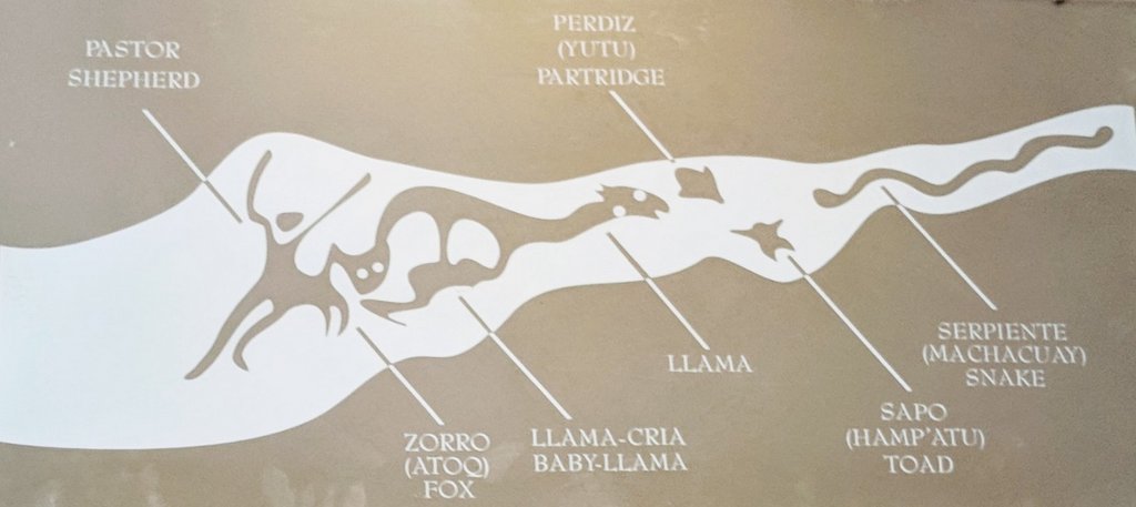
There are two main ways to find south in the sky, both methods using the Southern Cross. The first way is just to extend the Southern Cross 4.5 times and the tip of that will roughly land at the celestial south pole. The easier way for me was to connect the two pointer stars with a line, then imagine a line perpendicular to the original line. Where that perpendicular line meets the Southern Cross line is a point a bit above the celestial south pole. It seems more complicated, but was much easier for me to visualize. Once the navigators had established south, they could accurately orient their boat in whichever direction they wanted to travel even after the sun had set.
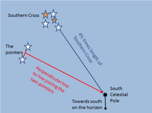
After all this time traveling in the southern hemisphere, I still struggle to recognize constellations. With so little light pollution, it was easy to see the bright stars and Milky Way. However, the main attraction was still to come when the guides took us to Anakena Beach. There they took photos of us with the moais and the celestial sky.

One of the guides starting singing a Rapa Nui song his father had taught him, using two rocks to make a beat. As he was singing, a rainbow appeared over the moais, made from the light reflecting from the moon and the moisture in the air. This “moonbow” hung in the air as the guide was singing and just as he finished, we could hear a set of hooves stampeding through the sand behind us. I turned and saw a herd of wild horses running along the beach. Music. Moonlit rainbows. Mesmerizing horses. Magic. Pure magic. Definitely a moment I will remember for a long, long time.

rapa nui

me and the moais, lunar rainbow over the moais

Like many people, I came to Rapa Nui to see the mysterious moais. They are supposed to be representations of revered ancestors who were supposed to be looking out for the best interests of the islanders. They started out small and got bigger over time. Many of the moais were placed onto specially designed altars known locally as ahus. During a hiking tour of the northern edge of the island, I got to see one of the earliest moais that was actually carved from the igneous rock basalt.

Starred Photos5

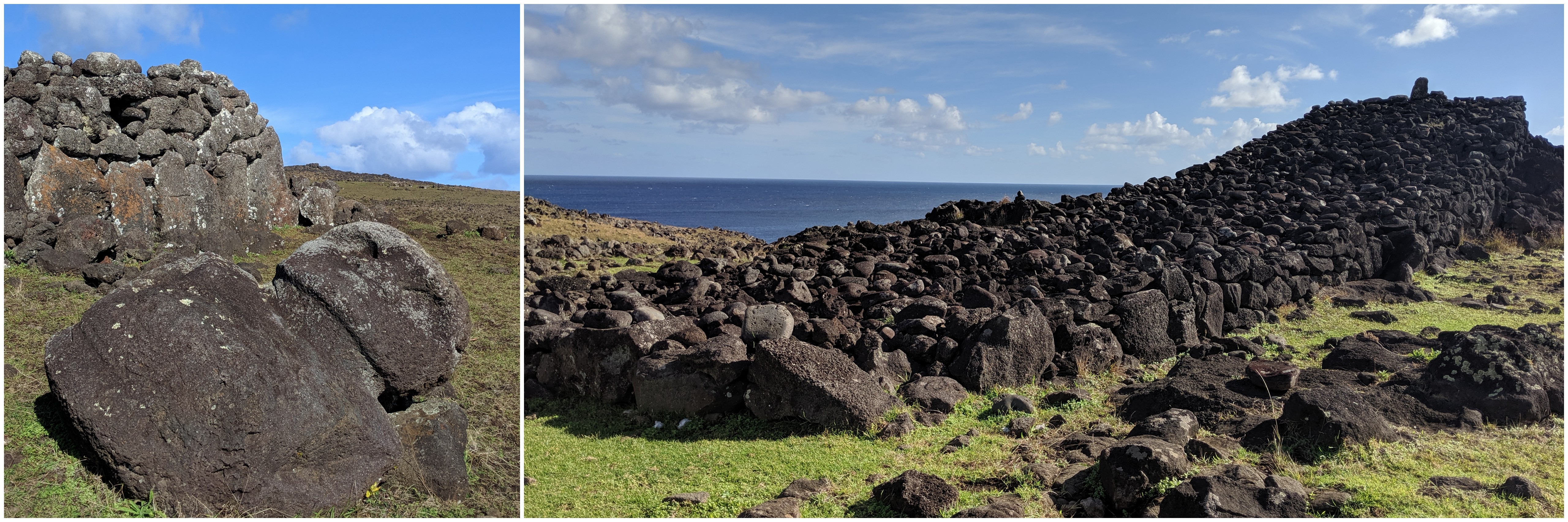
early moai, a giant ramp ahu (the only one like it on the island)

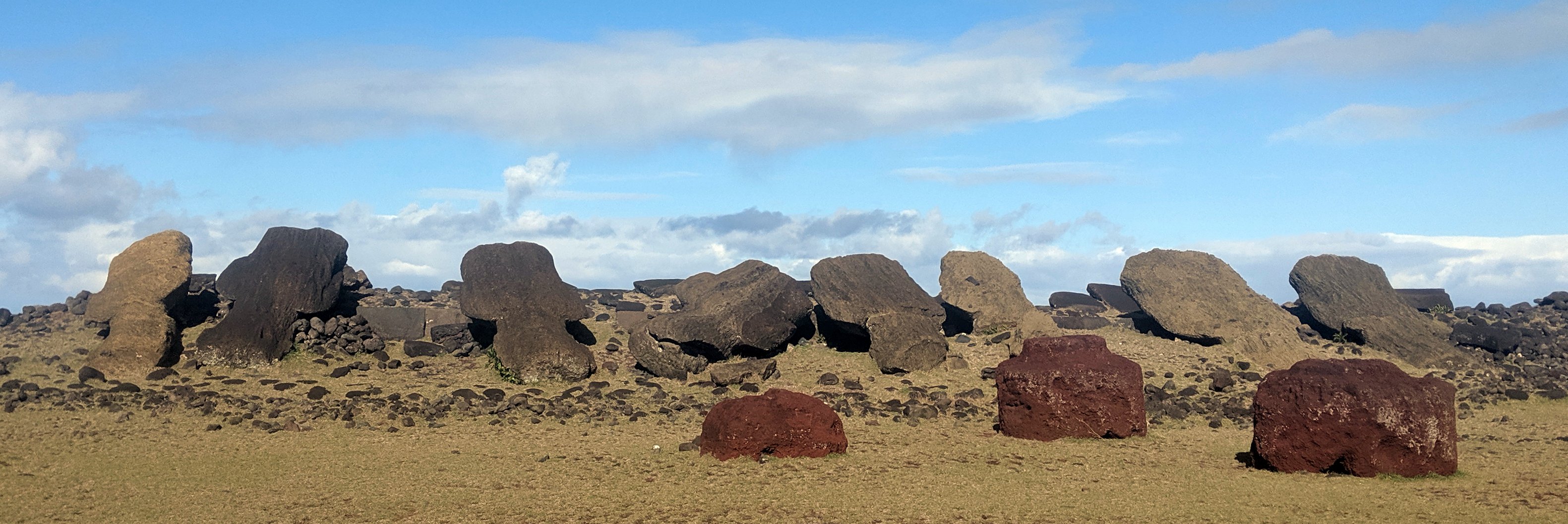
Most of the moais are sculpted from tuff, basically volcanic ash that has hardened and is much easier to carve. The later moais had tattoo carvings on their backs that were probably painted. Over time many of these tattoos have eroded away due to wind and rain. They also had topknots (pukaos) made of red scoria. Once the moai was moved and placed upon its ahu, coral eyes were added with pupils made of black obsidian or red scoria.

rapa nui1

reconstructed moais showcasing tattoos and eyes

A giant quarry at Rano Raraku was used to construct these moai and then oral tradition says they were walked into place. There is still contention about how they were moved, but the distances were great and an average moai weighed 14 tons. (The biggest moai ever moved and erected weighed 82 tons). The pukaos themselves each weighed 1-2 tons.

Starred Photos2

moais still in the quarry at Rano Raraku

Once placed upon their ahu, the islanders believed that their ancestors would make sure their needs were met. When colonizers first visited the island, they wrote in their journals about the moais still being upright on their ahus.

tongariki

Ahu Tongariki

However, over time, the islanders begun to have issues and grew unhappy with their ancestors not providing for them. Many researchers attribute this to overpopulation and a lack of resources, specifically related to deforestation. There was certainly internal conflict on the island and the end result was that the moais around the island were toppled and the worship of ancestors ceased. The quarry at Rano Raraku is still full of semi-completed moais that were never moved from where they were carved.

moaidown

toppled moais with a few of their pukaos

In recent years, several of these ahus have been restored and some of the moais have been placed back onto their altars so that visitors can understand what that would have looked like. Many others have been left facedown on the ground where they were pulled down years ago.

Starred Photos3

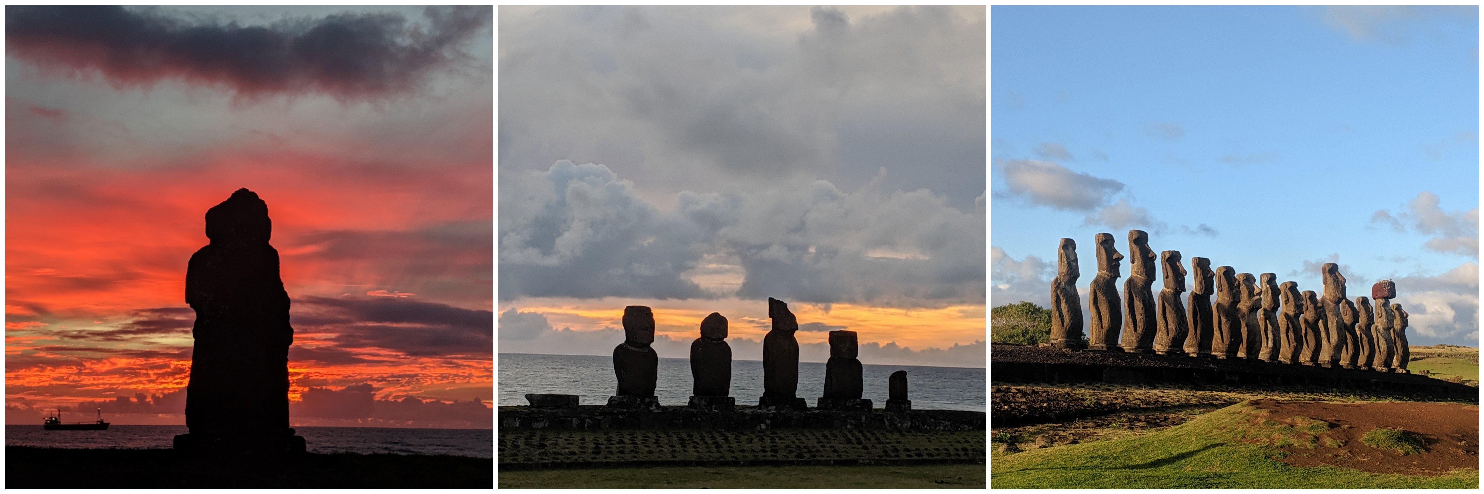
moais more recently restored onto their ahus

Most islanders used to live in houses made of rocks and plants. The igneous rocks were carved with small holes that the support beams were wedged into. Then palms were added to the outside. The boat shape held up well against the wind and the plants protected the residents from the elements.

Starred Photos1

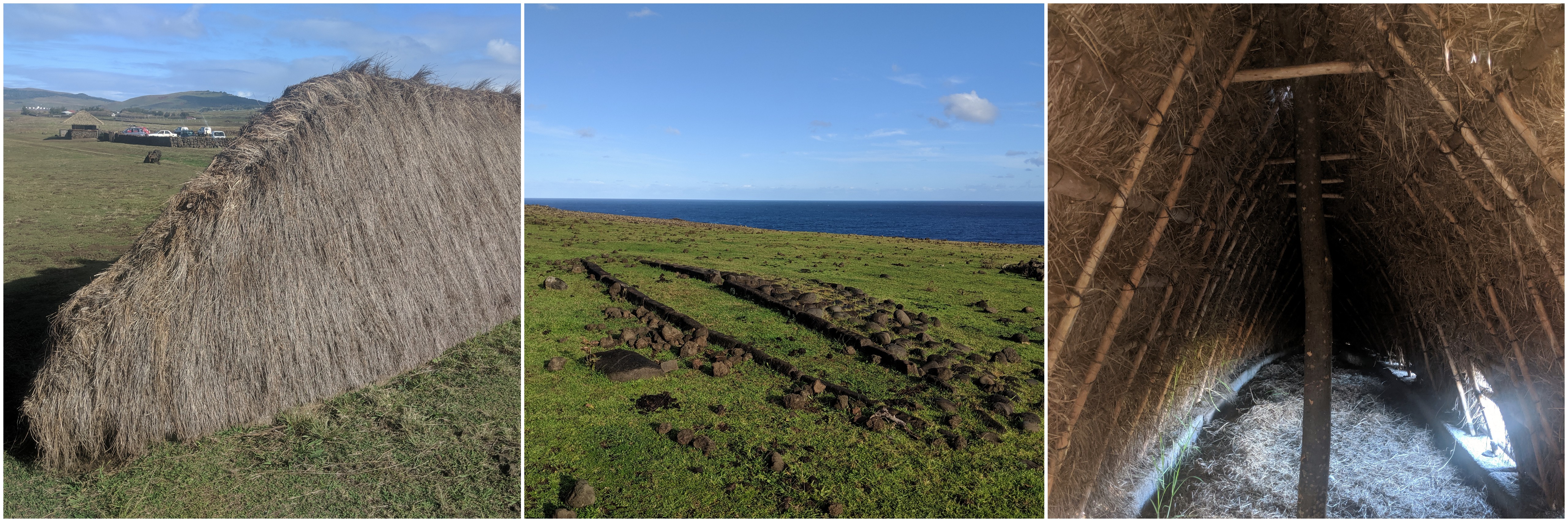
reconstructed house, stone remnants of houses found all over the island, inside of a house

In one part of the island known as Orongo, stone structures were built instead. This is because the winds were quite strong here and the other houses wouldn’t have lasted long here. These were also built much later, after the moais were taken down. This village was the home of the annual competition of the tangata manu. This event was part of the birdman cult in which Rapa Nui men competed to collect the first sooty tern egg from the island of Motu Nui and then swim it back to the Orongo village. That man would then be made the leader for the following year, although sometimes potential leaders chose a representative to compete in their place.

Starred Photos7

stone house at Orongo, the far island in the photo is Moto Nui, another stone houe

At this time, there were many petroglyphs carved all over the island. Some of the most common carvings included Make-make, the chief god of the birdman cult. Many also featured giant tunas and boats as well as carvings of vulvas, known as komaris.

Starred Photos.jpg

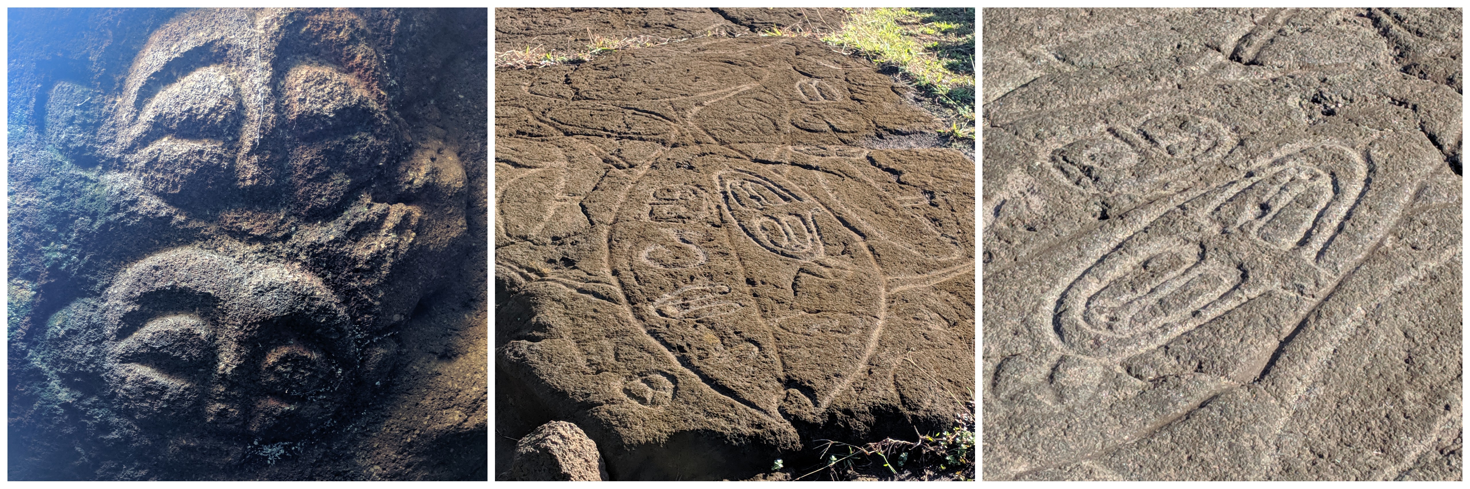
petroglyphs of Make-make, giant tuna, and a closeup of vulvas

On another hike to a restricted area known as Poike, we were take to a cave that had even more carvings. Women stayed in this cave from time to time for religious purposes and representations of their deities are carved in the wall. Also found on the wall were petroglyphs of sweet potatoes covered in small root hairs (apparently now only found at a couple houses on the whole island).

Starred Photos6

top: me while posing, female deities, sweet potato and stone tool
bottom: gorgeous coastline; a rock carved with a face; me, my hostel roommate Camille and our guide Yoyo

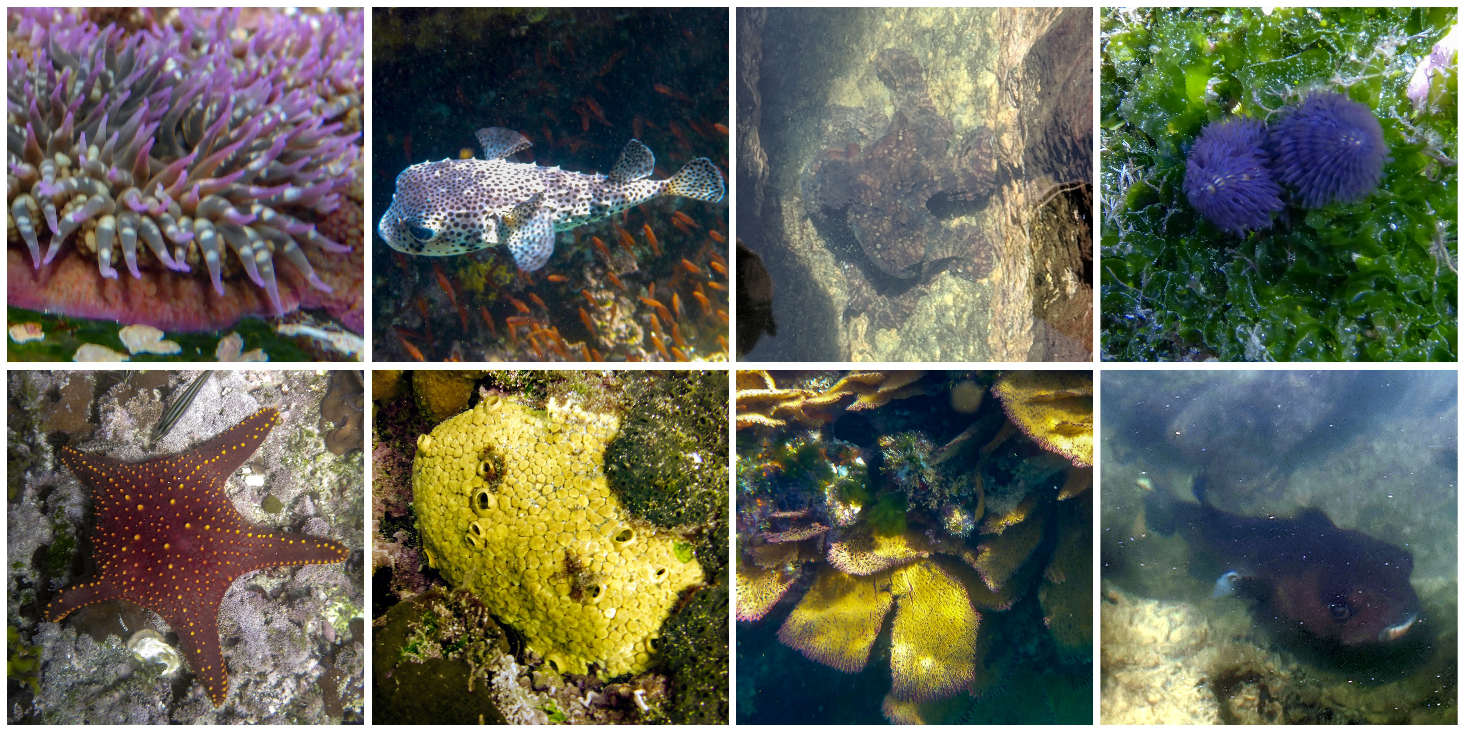
By now, you all know I love to see what’s under the water, so I spent one afternoon with my new French friends at the beach and we found a bit of marine life. The lizardfish was definitely a new one for me.

rapanui2

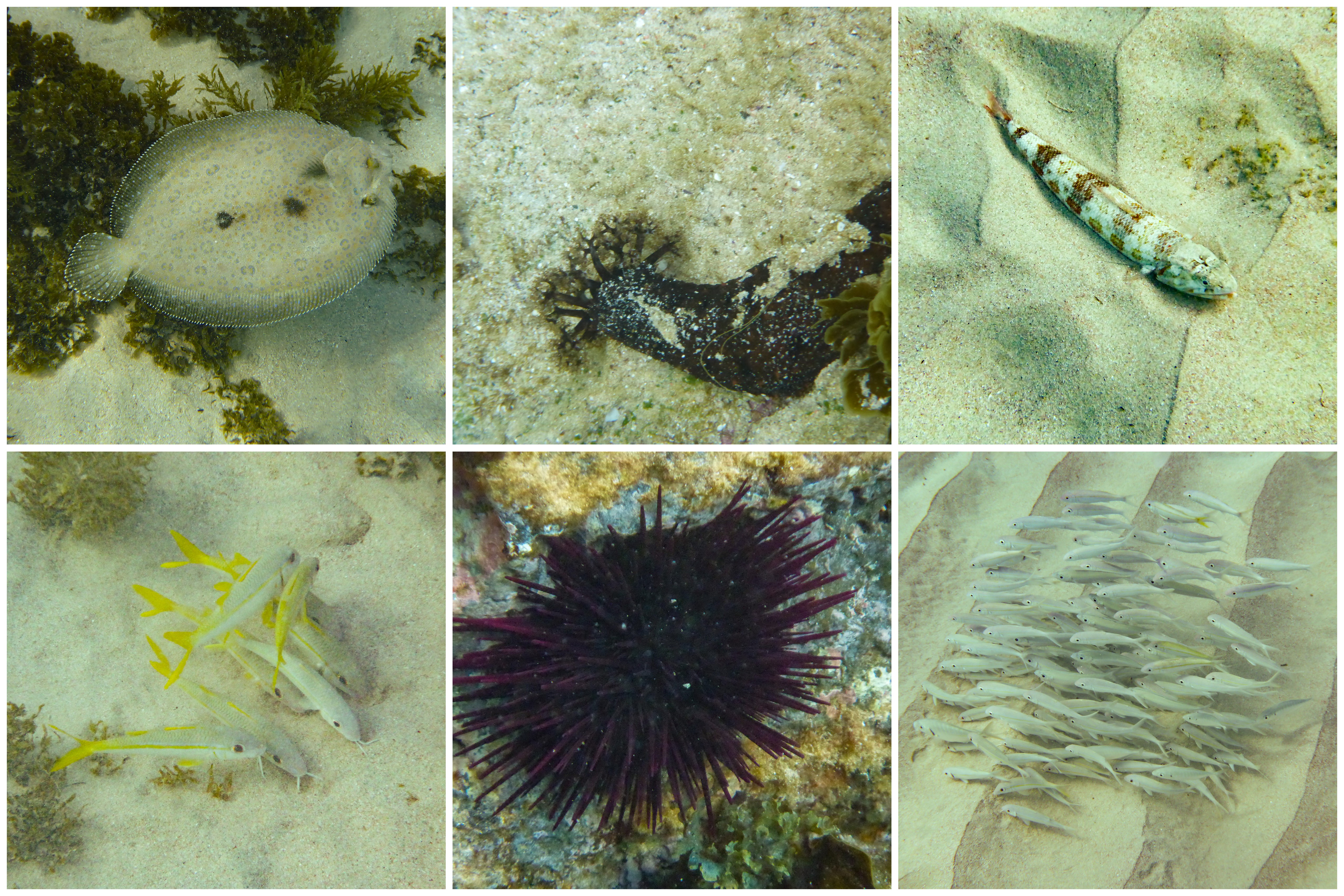
top: flounder, black sea cucumber, lizardfish
bottom: yellowfin goatfish, purple sea urchin, yellowstripe goatfish


Week 13 & 14: Puerto Natales & Torres del Paine

chileweek13.png

As soon as I knew that I was awarded a sabbatical, this was the part of the trip that I knew I had to do this year. Hiking in Patagonia can only happen during summer in the southern hemisphere, which is a time of year that I’d normally be teaching. Because I knew I’d have December free, I centered the rest of my trip around making sure I’d be at the tip of South America right now.

PUERTO NATALES

First stop en route to the park was the nearby town of Puerto Natales. It’s the town everyone passes through on way to the park. I spent a whole day getting supplies and packing up my things and managed to do a little bit of sightseeing along the fjord as well.

One of the most unique things I found out about were mylodons. They’re extinct ground sloths that would have been about 10 feet tall and weighed about a ton. Some very well-preserved remains were found in a cave nearby and brought the town a bit of fame in paleontology circles.

puertonatales.jpg

view of the fjord from Puerto Natales, life-sized statue of a mylodon, Monumento de la Mano

PARQUE NACIONAL TORRES DEL PAINE

The roughly 80 mile trip I did is colloquially referred to as the “O” because on a map it’s basically a big circle. A lot of people hike the “W” which is the bottom half of the “O” and is half as long. In the map below, the “W” is the blue line and the “O” is both the red and blue lines.

torresmap.jpg

Because I’m crazy and figured I’d only get this opportunity once in my life, I booked my campsites for the longer 9 day, 8 night trek almost six months ago. It’s a beautiful circuit of glacially carved landscapes and pictures will never do the actual views justice. Nevertheless, here are my favorite 3 photos from each day of the trek in hopes of giving you a small glimpse of the wonders of Patagonia.

Day 1: Welcome Center to Serontdp1
Day 2: Seron to Dicksontdp2.jpg
Day 3: Dickson to Los Perrostdp3.jpg
Day 4: Los Perros to Pasotdp4.jpg
Day 5: Paso to Grey (plus kayak to the glacier)tdp5.jpg
Day 6: Grey to Italianotdp6.jpg
Day 7: Italiano to Los Cuernos (including hike up the French Valley)tdp71.jpg
Day 8: Los Cuernos to Chilenotdp8.jpg
Day 9: Chileno to Welcome Center (including hike to the Torres)tdp9.jpg
Bonus PanoramasPANO_20181205_135806.vr.jpgPANO_20181206_163910.vr-001.jpgPANO_20181208_101814.vr.jpgPANO_20181209_095531.vr-001.jpg

This is, by far, the longest solo trip I’ve ever done. However, the path is filled with other amazing hikers and I never felt alone for very long. Since everyone is moving in the same direction and campsites are mandatory, I ran into people over and over again and made some true friends for life.

There are many things that went wrong on this trip. My stove was giving my trouble and I had to take it apart and put it back together twice. My aging backpack basically fell apart: one of the metal support spines broke, the front left pocket zipper is broken, and four growing holes appeared along pocket seams that I patched with duct tape. I tripped over a rock, leaving a big bruise on my left leg and my face was attacked by a couple of mosquitos. Yet somehow, looking back on the trip, I feel nothing but incredible wonder and joy for the beauty nature provides. The last few months have been a journey towards mental and physical healing and this trip took me a long way back towards feeling like myself again. Crazy, but blessed.


Week 12: Valparaíso & Santiago

chileweek12.png

VALPARAÍSO

Hanging out in Valparaíso was basically a vacation from my vacation. My former colleague Cata picked me up from the airport and whisked me to her beautiful place that she and her husband are running as an Airbnb. No buses and taxis. Just an old friend and conversation. After we arrived they showed me all over town and even invited me to a friend’s Thanksgiving celebration. I made a cherry blueberry pie (and Cata helped), because they are fresh in the market right now. (It’s summer here!)

valpo1.jpg

Cata and I posing next to beautiful art, view of Valpo, Cata learning how to weave pie lattice

Valparaíso is known for its beautiful murals and one of the coolest is on their hotel (the one with Van Gogh below). The best thing to do is just walk around town and run into awesome art. Here’s some of my favorite ones:

valpo.jpg

SANTIAGO

I finally had to say goodbye and headed into the capital city where I was able to indulge my love of museums and beautiful outdoor spaces. The most important place I visited was the Museum of Memory and Human Rights. Most of the museum is dedicated to exploring the terrible crimes committed while Pinochet was dictator. Many people were tortured, many died, and many disappeared (almost all of those were presumably killed). The museum is a reminder to never forget what happened under the oppressive regime, so as to hopefully make sure that it never happens again.

santiago1.jpg

tribute to people who died and disappeared under Pinochet, reminder that indigenous people are still here, the first article of the United Nations’ Universal Declaration of Human Rights

Just in case you wanted to read what that last photo says in English:

Article 1: All human beings are born free and equal in dignity and rights. They are endowed with reason and conscience and should act towards one another in a spirit of brotherhood.

If you’ve never read the Universal Declaration of Human Rights, it’s great and you should take a moment to look it over.  I had a simplified version of it up on my classroom wall. Read the whole document here.

I also visited several art museums! The quipu in the photo below needs some explanation. These were used in Inca times to record numbers, probably for taxation purposes. Powers of ten are signified by different regions along the strings and the numbers of knots at each location indicates how many digits are in each position. So for example 7 knots in the tens section and 2 knots in the ones section would mean 72. (Although this is a simplification because knots in the ones sections are actually done a bit differently). Scientists figured this out because there are certain strings that add up to all the previous strings. However, other quipus might show maps or other information and no one really knows what the colors are for. It appears the Inca didn’t have a written language, but these quipus are certainly part of their recorded history. (Note: Santiago was an Inca city, their empire stretched this far south.)

santiago2.jpg

exhibit at the Museo de Arte Contemporáneo, my favorite sculpture at the Parque De Las Esculturas, quipu at the Museo Chileno de Arte Precolombino

I also climbed a few hills to get some beautiful views of the city. I loved that Santiago is full of parks and nature spots. It makes the crowded spaces feel very liveable.

PANO_20181127_143221.vr.jpg
view from Castillo Hidalgo on Cerro Santa Lucía

The picture of the sunset below was quite nice, but the funicular that goes down the mountain stopped running at 7pm. The sun doesn’t set until 8:30pm, so I started walking down the hill as it was getting darker. Unfortunately, I hadn’t planned my route back very well and ended up on a mountain bike path (with fortunately no bikes on it). However, that path didn’t actually connect to the street, so I decided to go on a little adventure off trail and bushwhacked my way through plants as I basically slid down the rest of the hill. I was covered in tiny spiky plant parts, had a couple tiny splinters in my hand, and got several scratches on my leg, but I survived! 🙂

santiago3.jpg

view of Castillo Hidalgo on Cerro Santa Lucía, sunset from Cerro San Cristóbal

WANT A POSTCARD?

This offer is still valid. 🙂 If you want a postcard from overseas, fill out this postcard form! At some point this school year, I will send you a postcard from somewhere outside the United States. I just sent a bunch from Chile!

Week 11: Arequipa, Colca Canyon, Nasca & Lima

peruweek11

AREQUIPA

The White City of Peru, apparently named not only for the color of the buildings, but also because it was the city with the highest number of European immigrants. My two favorite parts of Arequipa were the queso helado and the incredible sunsets in the main square. Queso helado isn’t actually frozen cheese, but a delicious and yummy local ice cream.

arequipa.jpg

sunset over the cathedral, queso helado, sunset over the Plaza de Armas

Arequipa is known for the Santa Catalina Monastery, which is basically a small city within the city. Wealthy Spanish sent their daughters to live there until they died, paying a monthly sum for their daily upkeep the rest of their lives. Each nun basically had their own apartment within the complex, but weren’t allowed contact with the outside world except in one small room.

arequipa1.jpg

laundromats for the nuns, beautiful fountain, walkway of a plaza

COLCA CANYON

On the way to the canyon, there is a famous stopping point known as the Cruz del Condor where there are almost always Andean condors flying in the morning hours. This point is at the cross-section of winds and the condors ride them all morning scavenging for food. We saw quite a few before venturing on to start our trip into one of the deepest canyons in the world. This overnight hike into Colca Canyon involved a really, really long and really, really hot walk down into the canyon and a really, really steep hike out in the morning starting while there were still stars out.

colca.jpg

Andean condor, view from the start of the hike, view from the end of the hike

colca1.jpg

oasis where we spent the night, early morning hiking, hexagonal basalt columns

One thing I failed to capture on camera (sorry!) was my first introduction to cochineal bugs living on prickly pear cactus. Squishing them exudes a red dye that can be used to decorate skin and (if enough are harvested) color clothing. I’d seen these dried bugs in markets, but never actually seen them alive on cacti.

NASCA

The only real way to see the Nasca Lines is to get up in a plane, so I paid the money and hopped aboard a little prop plane to see these beautiful creations. They were made by digging small trenches that removed the top layer of gravel and exposed the subsoil underneath which is lighter in color. Their cultural importance is still up for speculation and there are way more designs than the ones here.

nasca.jpg

top (l to r): tree, monkey, spider
bottom (l to r): condor, hands, hummingbird

LIMA

I don’t usually take photos of museum pieces, but the Museo Larco in Lima is a pretty exceptional museum. I find the patterns on Nasca (also written Nazca) pottery to be stunning, so I thought I’d share a few of the more spectacular pieces. This type of art was actually the inspiration for many modern and cubist artists of the 20th century.

lima.jpg

Nasca pottery, top of a Nazca drum, close-up of Nazca pottery

Other highlights included skulls that were opened up in Inca times. This brain surgery would have been performed to help hematomas or remove parts of the skull that had been fractured in war. The skull on the left doesn’t show any bone regrowth so the person probably died from the effort. However, the one on the right shows lots of growth so that person lived quite a while after the surgery was performed.

Also on display were sculptures depicting cultural scenes, textiles covered in feathers, and rooms full of jewelry. Many rulers of early Peruvians wore giant earplugs as a symbol of status. Some of these are 3-4″ across, so you can imagine how large their earlobes had to be stretched to accommodate these works of art.

lima1.jpg

skulls after surgery, decapitation ceramic, mosaic Moche ear plug

WANT A POSTCARD?

This offer is still valid. 🙂If you want a postcard from overseas, fill out this postcard form! At some point this school year, I will send you a postcard from somewhere outside the United States.

Week 10: Puno, Inca Trail & Cusco

peruweek10

PUNO

An early morning boat ride whisked me out to the floating islands of the Uros on the Peruvian side of Lake Titicaca. This is a group of people who were sick of fighting with other people on the mainland, so they made their permanent home in the middle of the lake on artificial islands they made out of plants. The woman in the photo is demonstrating how this works: a large layer of floating roots tied together, followed by reeds, then houses go on top. The plants are constantly decomposing, so there is constant work to maintain and upkeep the islands and structures.

puno.jpg

floating reed islands (with solar panels), explaining how the reed islands are built, incredible reed boats

INCA TRAIL

Day 1: We left before the sun rose and the first day was a relatively easy wander along the Willkamayu River (also known as the Urubamba). To the Incas, this river was the earthly version of the Milky Way and reflected the duality between the heavens and the land. After passing the agricultural city of Patallacata, we camped in the middle of some gorgeous mountains.

incaday1.jpg

start of the trail over the Willkamayu River, Patallacta, view from evening campsite

Day 2: This was a shock to the system with a never ending set of stairs towards Dead Woman’s Pass, named because of the shape of the mountain. I’d been at pretty high elevation for the last two weeks, but I was still moving slowly, especially towards the top. There’s a lot of ups and a lot of downs, but the scenery and company was fantastic.

incaday21.jpg

hiking through cloud forests with awesome people

incaday2.jpg

on the way to the pass, celebrating making it to the top, the view down from the pass

Day 3: After waking up at the break of dawn, we headed out for a full day of ruins. In the morning we stopped at the beautiful temple of Sayamarka.

incaday3

cloudy view from Sayamarka window, chillin’ in the old temple, flowers growing from a crack

PANO_20181112_094313.vr.jpg

view of Sayamarka

Although the rain picked up after lunch, we were able to visit more Inca sights after lunch. Their splendor and size got grander as we got closer to Machu Picchu. The current theory is that Machu Picchu was a country estate designed for the Inca ruler Pachacuti. When he left Cusco, he would take up residence in this citadel. As his entourage moved along the Inca Trail, there would have been teenage sacrifices (some self-chosen and some chosen by parents) and celebrations in his honor. For this reason, there is a sacrifice table at one of these temples and the blood would run from this spot higher up to the temples at the bottom of the mountain through a series of canals.

incaday31

Phuyupatamarka, the group in our colorful rain gear, Intipata

Our guide gave us a special evening tour of the beautiful ruins of Wiñay Wayna. Inside of this temple there would have been an Inca mummy that continued to dispense advice and wisdom even after death.

incaday32

view of Wiñay Wayna, after dark special effects

Day 4: One last ridiculously early morning and we were finally on our way to Machu Picchu.  The clouds were out as soon as we started walking, so there were no beautiful views. The spectacular tourist shot that everyone takes was a giant cloud when we went by. After dropping our bags off, we went off on a tour of the ruins. Machu Picchu has a little bit of everything: deluxe bedrooms, temples, vast terraced agricultural lands, educational spaces, intensive plumbing, and astronomical observatories. I had gotten a ticket to climb Huayna Picchu, but after 4 days of non-stop hiking, I only made it up the slightly smaller hill nearby to capture a photo of its incredible beauty.

incaday4

Sun Temple, Room of Three Windows, Intihuatuana (used for observing astronomical events)

PANO_20181113_085949.vr.jpg

Machu Picchu in the clouds

incaday41

Machu Picchu, me and our guide, view from nearby hill

By the way, if you’re looking for a company to hike the Inca Trail with I highly reccommend Evolution Treks Peru. They’ve got women porters, excellent guides, and treat their workers extremely well.

CUSCO

I ate a huge meal of Chifa (Peruvian-Chinese food served with limes and ají) and promptly fell asleep at 8:00pm. When I woke up, my calves were a tingling mess of soreness, but I endeavored to get moving regardless. I wandered through some museums and markets, but my highlight was going to the family-run Cusco Planetarium. I learned all about the black llama that can be seen in the Milky Way. Its eye is one of the pointer stars to the Southern Cross. In addition, I found out that Incas most likely used the Pleiades to determine whether or not they were going to have an El Niño year. When they were bright and clear they would have a regular year, but when they were blurry and faded, they would have an El Niño year. This has do with the arrangements of winds, weather, cloud cover, and geography (scientific article in Nature).

IMG_20181115_111851

Milky Way dark constellations (from display at Qori’kancha)

I also spent a day exploring some ruins near to Cusco known as Inkilltambo, the Garden Hostel. There were beautiful terraces for agriculture, a jail, and a place for storing grain. The Inca empire mastered agriculture in a very difficult and mountainous terrain. Even the Spanish recorded that no one was hungry in the Inca Empire. (This can probably be attributed to the m’ita system of forced labor, which has some elements of public service and some elements of straight-up oppression).

cusco.jpg

Inkilltambo: sacred rocks, grain storage, reconstructed housing

WANT A POSTCARD?

This offer is still valid. 🙂 If you want a postcard from overseas, fill out this postcard form! At some point this school year, I will send you a postcard from somewhere outside the United States. I can’t guarantee it will be delivered, but I will send it. The first set of postcards has already departed Peru!

Week 9: Uyuni, La Paz, & Copacabana

boliviamapweek9.png

UYUNI

I came to Bolivia specifically to see the Uyuni de Salar (salt flats of Uyuni). A geologist on my Antarctica trip recommended it to me and it’s been on my wish list ever since. When it rains, people take incredible photographs of the reflections, but since I was there on a very dry day, we took lots of fun optical illusion photos instead. Because there is nothing to help your eyes gauge distance (trees, houses), objects that are very far apart can be creatively arranged in such a way that they look like they are the same distance (albeit with different sizes)

uyuniuyuni2.jpg

In the middle of the salar, there are islands covered in slow-growing cacti and fossilized corals. The salt flats were once giant saltwater lakes that slowly dried out over many years because their link to water was closed. Remember these salt flats are at almost 12,000 ft in an area that gets little rain. The islands that stick up now would have been seamounts in the old lakes, covered in marine organisms. Over time, as the sea level dropped, these landmasses emerged out of the water and new life forms gradually colonized them.

PANO_20181031_163447.vr.jpg

view of the Salar de Uyuni from Isla Intahuasi

After the salt flats, we spent most of the next day looking at flamingos. I always thought these creatures lived in hot areas, but these species like the high altitude. My favorite were the Andean flamingos, which have wide red stripes and black tips on their wings that can only be seen when they fly.

uyuni1

flamingos, flamingos, and more flamingos (close ups are hard because they’re so skittish)

I was also excited to see a few more creatures I’d never seen before. The vicuña is a relative of llamas and alpacas (in the camelid family), but so far have escaped domestication. Because of this, their wool is the most expensive in the world. The Andean fox, like foxes everywhere it seems, is incredibly shy. This one was hovering near our lunch spot, just out of range, most likely waiting to enjoy some crumbs after we left. And last, but certainly not least, is the incredibly large rodent known as the viscacha that looks like a combination between a squirrel and a rabbit. It’s about the size of a jackrabbit, but in reality, is more closely related to the much smaller chinchilla.

uyuni3

vicuña, Andean fox, viscacha

Near the end of the trip we stopped at the Sol de Mañana, a geothermally active region near the border with Chile. It reminded me so much of Yellowstone National Park, full of steaming hot water, fumaroles, and a strong smell of sulfur.

PANO_20181101_161534.vr.jpg

Sol de Mañana

Mud pots are just collections of dirt and boiling hot water. I tried out my phone’s slow motion setting and found the way the bubbles burst to be mesmerizing so I thought I’d share.

LA PAZ

I arrived on a night bus from Uyuni, not quite sure what to do with myself with hours to kill before I could check in at the hotel. I ate a huge breakfast and wrote tons of postcards before finally wandering over to the Iglesia de San Francisco, which included some great views from the roof. The tiles on the roof were made using people’s legs as molds which is why they are slightly different sizes and shapes.

lapaz.jpg

view from the roof, the tiled roof, me in the tiny stairwell

My favorite part of La Paz was riding the cable cars everywhere. For less that 50¢, I saw incredible views. Because of the tremendous difference in elevation between different parts of the city, cable cars make more sense than subways or bus lines. The president Evo Morales finally pushed through this amazing public transportation system that goes all over the city.  (In case someone forgot that he was taking credit for this achievement, his face is plastered on every single cable car.) Another unique La Paz attraction is the clock that runs counterclockwise on the Bolivian Congressional Building. Apparently, this was installed to represent how sundials actually move in the southern hemisphere and symbolically celebrate that difference.

lapaz2.jpg

Mi Teleférico cable car, Bolivia’s “clock of the south”, street art

COPACABANA

No, not *that* Copacabana. This one is on the shores of Lake Titicaca. In order to get there, the bus had to go on a separate ferry over the Straight of Tiquina. I climbed up a big hill to see an Incan stone doorway that lets light through on the summer solstice and although that was a bit disappointing, I did get a wonderful view of the city.

copa.jpg

bus on a ferry, view of Copacabana from a nearby hill, Copacabana sunset

The next day, I rolled out of bed to catch an early ferry to the Isla del Sol, a small island located relatively close to the mainland. There is an ongoing feud between different communities on the island, so visitors can only go the southern part of the island. I hiked up to the top and decided it seemed like a beautiful place to read and enjoy the scenery.

copa2.jpg

view from Isla del Sol to the mainland, view of another part of the island from the same spot

WANT A POSTCARD?

Here’s a reward for making it to the bottom of this blog post. 🙂 If you want a postcard from overseas, fill out this postcard form! At some point this school year, I will send you a postcard from somewhere outside the United States. I can’t guarantee it will be delivered, but I will send it.

Week 8: Sucre & Potosí

boliviamapweek8

SUCRE

After my weekend getaway to vote (VOTE, PEOPLE!) and see some friends, I flew into Sucre in Bolivia. One of the highlights was stopping at the San Felipe de Neri which is a beautiful colonial convent and church. I helped a nun take a picture with a friend of hers and she then decided to show me the underground crypt where nuns had previously buried. We literally opened a door in the floor in one of the rooms to step down into the all white room.

sucre.jpg

view from the roof, patchwork tiles on the roof, me & the gorgeous view of the city

PANO_20181026_175036.vr-001

view from the rooftop

But really, my favorite place was the Parque Cretácico which contains a giant wall full of dinosaur footsteps.

PANO_20181026_125115.vr-001

the wall!

The footsteps were discovered when the cement factory was digging through rocks and finally decided the limestone they were digging wasn’t good enough. They stopped and a few years later, the clay and dirt on the outermost layer eroded to reveal the footsteps beneath.

PANO_20181026_123118.vr-001.jpg

dinosaur footsteps!

About 68 million years ago, this was a shallow lake bed and dinosaurs happened to walk through it. Luckily, enough sediments were deposited in a short enough time, that those footsteps became fossilized in the rock. This area is prone to a lot of volcanic action and plate tectonic movement and over time, this particular rock was tilted all the way up into the vertical position it is in today. There are four types of dinosaur footprints: theropods (like velociraptors), ankylosaurus, ornithopods (like duck-billed hadrosaurs), and sauropods (like brontosaurus). The sauropods in this case are most likely Argentinosaurus, which is a truly giant creature that is pretty awesome. You should probably take a moment and Google it now. In the photo below, see if you can identify the different footprints.

sucre1.jpg

footprints, guide to the footprints, and my favorite strange angle photo of a sauropod replica

POTOSÍ

Onwards to one of the highest cities in the world at 4,067 m, which is known for its extremely dangerous and deadly silver mines. (Side note: Altitude headaches suck.) I arrived on a Sunday when hardly anything is open, but set off to explore anyways. I heard music playing, so I wandered in that direction until I found a dance competition about to begin and I, of course, stayed to witness the incredible talent.

potosi.jpgpotosi3.jpg

The next day, I went on a tour of the infamous silver mines. During conquistador times, Incans were forced to work in the mines. When too many of them became sick or died because of the work, the Spanish important tens of thousands of African slaves. Guayasamín (the Ecuadorian painter I mentioned in an earlier blog post) has a painting called Potosí in the main dome in the atrium of his museum. It depicts the suffering of the miners after a collapse as they struggle to reach for the light. There are still deadly accidents, 5-10 people die every year, but at this high elevation there are little other options except to leave and find work in Santa Cruz.  Silicosis, a disease that damages the lungs when too much silica gets in, also shortens the life expectancy of miners.

My guide to the mines had worked in them for twelve years and although the pay of a miner is better (~1000 Bolivanos/week  = $145 US), the risk of dying is much higher. There are a bunch of cooperativas that own specific concessions (entry points) into the mine. Within the cooperative, people work with teams and their teams are paid based on the quality and quantity of rocks they dig. Although in the past, the main mineral of interest was silver, tin and zinc are now the main ores being mined.

potosi1.jpg

cooperativa, carts used to haul rocks, one of the entrances with Cerro Rico towering above

Miners are superstitious and believe that El Tío, a satanic lord of the underworld, watches over the mines. Whenever miners enter, they stick a lit cigarette in his mouth, ask for protection, and then shower his head, hands, and penis in coca leaves and 96 proof alcohol. There is an El Tío statue at almost every entrance into the mines. The miners believe that his needs must be satiated or he will cause their downfall. Llamas are also ritually slaughtered and their blood is splashed on the wall (see black marks in photo below).

potosi2.jpg
inside of the mine, me and El Tío, zinc oxide stalactites (not mined, just cool looking)

My last stop was the the old mint, which in colonial times, used the silver found in the mines to make coins and made Potosí one of the richest places in the world for awhile. Silver was removed from the mined rocks using the patio process, which involved creating a slurry of rock, salt, water, copper sulfate, and mercury. Eventually the mercury and silver would settle out of this solution and that alloy was taken to indigenous (and later African) slaves who melted it down. The heating process evaporated the mercury, leaving behind pure silver. Unfortunately, the toxic mercury fumes blinded the men and then killed them in about 3-4 months. (Between the mines and the mint, tens of thousands of slaves were killed in Potosí.) The silver was poured into molds and then those blocks of silver were brought to a series of three different sized rollers where they were fed through until they were the right thickness (like a pasta maker, only much hotter and requiring two people with tongs to hold above and below).

potosi5.jpg

furnace scene, silver ingot molds, rollers for thinning the blocks of silver

The rollers were each attached to a giant wheel that was turned by a gearing system on the toothed ring. That ring was constantly rotated by four mules below which powered the rollers in the room above.  Apparently, the best job in the mint was whipping the mules to move faster, because every other job was much more dangerous or deadly.

potosi6.jpg

up close of roller attached to wheels, wheels moved by toothed ring, ring moved by mules

At first, the money that was created was mostly silver and very malleable, but over time it was mixed with copper to create a harder, more resilient coin. If you look carefully at the last two coins, in the lower left there is an embossed mark that shows it was made in Potosí. It is a P, T, S, and I layered on top of each other. The guide told an elaborate story about how this eventually became the dollar sign ($), but I’m not so sure.

potosi4.jpg

very old all silver coin, 8 reales (piece of 8) from Spanish empire era, first Bolivian coinage (with llamas!)

On one last note, supermarkets in Potosí take their holiday decorations very seriously. Happy Halloween!

IMG_20181029_184359_1.jpg

Week 7: Trujillo & Lima

peruweek7

ECUADOR-PERU BORDER

Traveling south from Ecuador, I took a couple of buses for some long travel (14 hour-ish) into Peru. The border between Ecuador and Peru is full of Venezuelan refugees sleeping and waiting to be let in. UNHCR has water and medical stations set up to help, but I’ve never seen a border crossing like it in my entire life. The economic meltdown has led to millions of Venezuelans leaving their country and flooding into neighboring regions. Read more about it in this BBC article. Although many Latin American countries have been very receptive, the flow of refugees hasn’t ceased, which is leading to backlogs and countries starting to close their borders and the situation I witnessed.

TRUJILLO

Trujillo is known for having some of the most amazing Pre-Columbian ruins in South America, which seemed like a great reason to stop. I set out on a daylong tour to explore and our first stops were to see building constructed by the Chimú empire around 1300 AD. They are called huacas, which translates to tombs, but seemed to be used more for ritual sacrifice and other religious purposes. Their empire used to span a huge part of present-day Trujillo right up to the ocean. Although the area is quite arid now, presumably back in the day it was more lush because sea otters and squirrels are found engraved in the walls.

trujillo2.jpg

sea otter engravings at La Huaca Arco Iris and squirrel engravings at La Huaca Esmeralda

The next stop was Hacienda Chan Chan, a sprawling structure in which some parts have been extensively rebuilt. Before these buildings were found, they were protected by the sand and mud that had accumulated around them. Being exposed to the weather has worn down many of the engravings and there is much work that has been done to try and protect what is currently open to the air.

trujillo.jpg

pelican engraving, view of remodeled section of Hacienda Chan Chan, geometric pelican engraving

Next up was La Huaca de la Luna, and a trip back even further in time to learn about the Moche. This sight has one of the most extensive museums I’ve seen so far with elaborate explanations of cultural rituals. This place was built over many centuries, ending around 600 AD. Many ceramics and carved wall paintings have survived and so much more is known about these people, including their practice of ritual sacrifice and that those practices changed based on whether or not they were experiencing an El Niño. Just to emphasize, the Moche knew about El Niño over 1500 years ago.

trujillo1.jpg

engravings of spider crab, head deity Aiapaec the Decapitator, octopus legs

IMG_20181016_164908.jpg

incredible painted engraved door

LIMA

I had a 12 hour stopover in Lima and I really did see many things: catacombs under the Monastery of San Francisco, the coffin containing the bones of conquistador Francisco Pizarro (a.k.a. the murderer of the Incan emperor Atahualpa) inside the Cathedral, and an incredible art museum (I’m in love with the Peruvian graphic designer Elena Izcue who took her inspiration from Nazca pottery). However, perhaps because I was still sleepy or because photos weren’t allowed in some of these spots, I have no photos to share except for a protest I passed which I believe had something to do with the Fujimoris (the former president’s daughter had recently been arrested for money laundering). Nevertheless, I thought the imagery of this bird overlooking the police officers was both creative and symbolic.

IMG_20181017_173502

Week 6: Quito, Baños & Cuenca

ecuadormapweek6

QUITO

After the Galápagos, I headed back to Quito for a couple of days. I took the TelefériQo up a mountain which overlooks the city. The ride takes about 20 miles and goes up about a half a mile in elevation! Once I got to the top, it was really cloudy, but at some point, the clouds finally parted and I could see a little bit of the extensive city below.

quitopanoNot much was open because it was a national holiday, the celebration of the Independence of Guayaquil. I decided to head to a giant tourist trap – El Mitad del Mundo – the self-proclaimed middle of the world. The yellow line is supposed to indicate the equator, but really it’s off by more than a few meters. Photos3Because I’m a huge nerd, I wandered down the main highway quite a bit and finally found the actual GPS-based equator. 🙂

equator

Before I left, I also stopped in La Capilla del Hombre, the museum dedicated to the work of the Ecuadorian painter Oswaldo Guayasamín. He was outspoken about human rights violations and his art relies heavily on symbolism. During the personal home tour, one room was full of paintings of Jesus while the next contained a huge glass cabinet of pre-Columbian ceramics depicting different sexual positions. Inspiration can come from all sorts of places I suppose.guayasamin.jpg

BAÑOS

Up next was the tourist town of Baños. Some people stay here for a week, but I just popped in for a couple days. The town is beautiful and there are waterfalls everywhere.

banos

town church, waterfall in town, biking sign on Ruta de las Cascadas, waterfall outside of town, ponche suizo (a mix between a milkshake and a mousse) – still not sure how I feel about it.

I biked about 20 km to see a bunch of the waterfalls outside of town. My two favorites were El Pailon del Diablo (Devil’s Cauldron) and Cascada Machay. I had to hike and then crawl through a small cave that was less than a meter high in some spots to get close to the giant Pailon del Diablo. I emerged soaked, but the rainbow was beautiful. Cascada Machay seemed almost elegant in its simplicity.

banos1.jpg

El Pailon del Diablo, perpetual rainbow at its base (as long as there is sun), Cascada Machay

CUENCA

Next up was visiting friends of mine from Peace Corps Morocco. They own a farm on the outskirts of town and it was definitely one of the highlights of my trip because I got to milk a cow for the first time!!!

Photos5.jpg

cow milking, farm family photo (including volunteers staying on the farm)

In addition, Julie & Luke invited me to learn how to make cheese (in industrial farm-sized quantities). They can make more money in town selling their cheeses than they can selling milk. In the photos below, we’re making manchego. FYI: Hacienda Chan Chan has rooms available if you want to learn about cows, sheep, pigs, turkeys, ducks, chickens, milking, cheesemaking, etc. They were such gracious hosts and are such down-to-earth people. ❤

Photos4.jpg

cutting the curds, whisking them to make them smaller, stirring for hours as the heat is raised, the whey is emptied and fed to the pigs, the curds ready to be pressed into blocks of cheese

After a much too short reunion, I headed into the city of Cuenca. The town is full of colonial architecture and is known for making Panama hats. Panama hats were always made in Ecuador, but exported to Panama to be sold because there was more tourism there. People took them home and when others asked about the hats, they said they had gotten them in Panama. Over time, the hats became popularly known as Panama hats. Locally, they are called el sombrero de paja toquilla. As it was a Sunday, there wasn’t that much to do, and I didn’t have a chance to buy a hat or tour one of the many hat museums. However, I did get this shot from the Mirador de Turi looking out over town.

PANO_20181014_121250.jpg

Week 5: Galápagos Continued

galapagos2

The last 5 days, I lived aboard a beautiful sailing catamaran in the Galapagos and I’m not even sure how to describe all the incredible things I saw. Every day was filled with gorgeous new marine and land creatures. Probably the best way to share is to continue with another picture dump of awesome animals! (As always, there are probably mistakes in my species identification.)

ISLA SEYMOUR NORTE

This island is all about the birds! I booked this day trip just so I could see that crazy red-puffed up chest which the frigate bird is doing to attract females.

North Seymour_11.jpg

top (l to r): male magnificent frigate (inflating chest), male magnificent frigate sitting with new chick (maybe a week old), land iguana
bottom (l to r): juvenile great frigate, juvenile magnificent frigate, blue footed booby

ISLA SANTA CRUZ

Before the boat set sail, I did a little exploring on Isla Santa Cruz on my own.

Photos (1)

top (l to r): polychaete worms, bullseye pufferfish, sponge, sea cucumber (with poop)
middle (l to r): hard coral, lava lizard, ground finch, Galápagos dove
bottom (l to r): me being silly, juvenile turtles at the breeding center at the Charles Darwin Research Center, posing with Santa Cruz land tortoise (in a reserve), Santa Cruz land tortoise

ISLA ISABELA

Everything from here on out is from the cruise! Most of these places you can’t see unless you book a cruise ship. It’s expensive, but there are no words to express the beauty of the western Galápagos Islands.

isabela

top (l to r): Isabela marine iguana, Galápagos flamingo, lava heron, lava cactus
bottom (l to r): Isabela land tortoise (in the wild), Isabela land iguana, iguana vs turtle faceoff (guess who moved? answer at bottom), me with a land iguana

isabela1

top (l to r): sea anemone, spotfin burrfish, octopus, polychaete worms
bottom (l to r): Panamic cushion star, yellow sponge, gorgonia corals, giant porcupine fish

ISLA FERNANDINA

fernandina.jpg

top (l to r): swimming marine iguana, marine iguana eating algae (yes, underwater), baby Galápagos sea lion, Galápagos sea lion sunning itself
bottom (l to r): Sally lightfoot crab eating a squid, blue-striped sea slug, Galápagos penguin, flightless cormorant

One of the few places on earth you can actually swim with penguins.

ISLA SANTIAGO

santiago.jpg

top (l to r): female Galápagos fur seal (which is actually a sea lion not a seal), baby Galápagos fur seal (right before it vomited), yellow-crowned night heron, cushion sea star middle (l to r): green sea turtle, guinea pufferfish (mid-color transition), Moorish idol angelfish, king angelfish bottom (l to r): sea anemone, polychaete worms, barnacle, me snorkeling!


The Galápagos is truly one of the most incredible places I have ever been in my entire life. Shout out to the amazing crew and guide on our boat as well as sharing the last few days with great company. This is one place I would love to come back to. There is still so much more to see!

img_20181006_144006-e1539052161218.jpg

Answer: The land iguana moved out of the land tortoise’s way!