Biking the C&O and GAP Trail

Some of you have been following along on this journey through social media, but I wanted to put a record of this trip here. I biked the old Chesapeake and Ohio (C&O) Canal and the Great Allegheny Passage (GAP), which follows old railroad lines from the Baltimore and Ohio Railroad, Pittsburgh and Lake Erie Railroad, Union Railroad, and Western Maryland Railway. These trails are mostly gravel, although some parts are paved near the cities, and they are relatively flat or have very gradual elevation increases or decreases. Rail trails like this are so much less stressful than the highway rides I’ve done in the past. Some days, the riding was so smooth I had entire phone calls with friends and family while biking. I never really thought I’d get into long-distance bike touring, but it’s really a delightful way to see the world. Fast enough to actually see lots of places, but slow enough to notice what’s happening around you. One of my favorite part of these trails was the incredible amount of wildlife along the trail that I got to see — owls, herons, snakes, deer, turtles, groundhogs, and more.
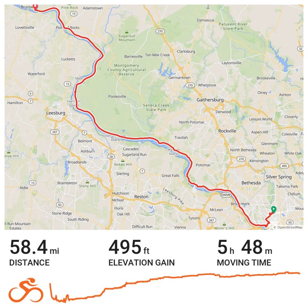
What a wonderful day of wildlife along the C&O Trail. I saw 2 owls, at least 5 great blue herons, 1 snake, 1 great heron, at least 4 deer, and a couple woodpeckers. 🚲 58 miles
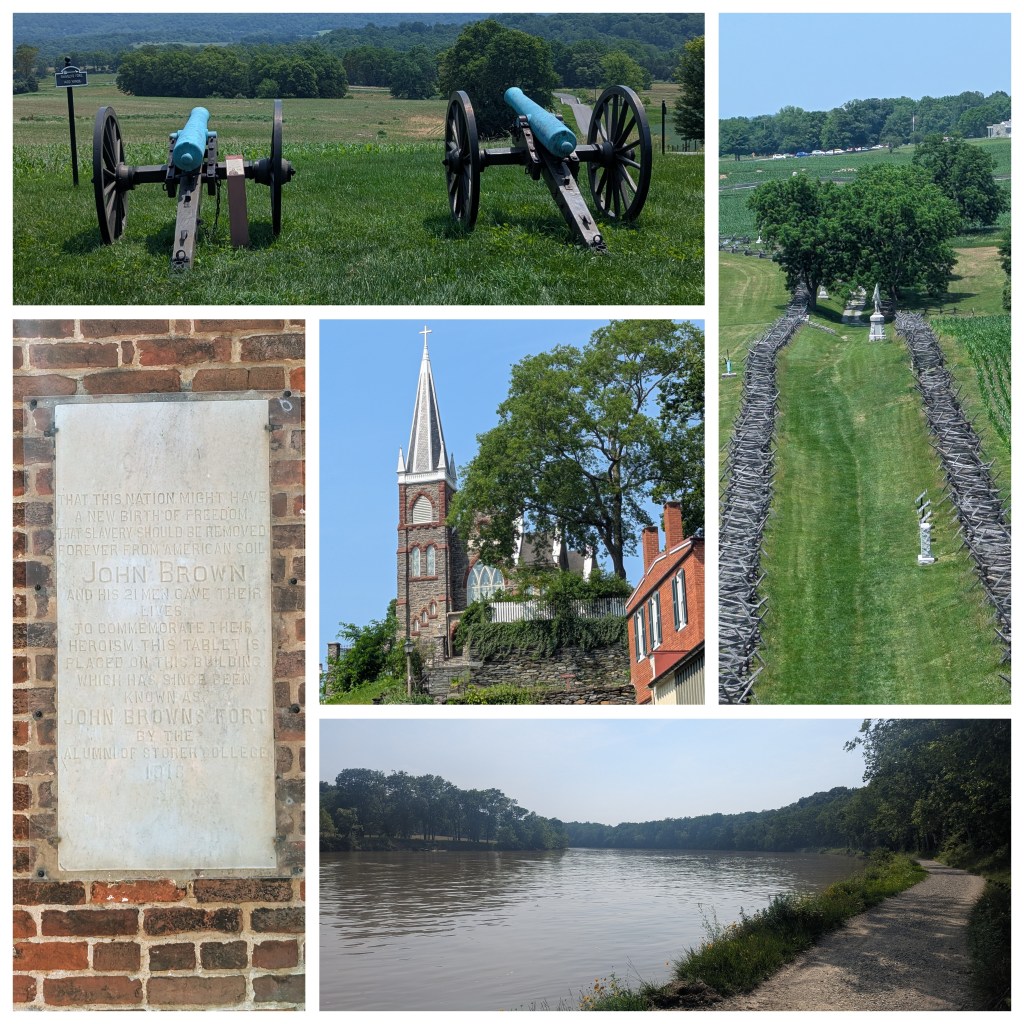
Delicious breakfast followed by lovely forest riding before I stopped in beautiful and historic Harper’s Ferry. Took a hilly, hot detour to the Civil War battlefield of Antietam before heading back for a lovely afternoon along the Potomac. 🚲 51 miles

Slow, steady uphill grind today on muddy, gravel trails. Stopped to see Fort Frederick (built for the French and Indian War), a cement factory, as well as admiring all the tilted rock layers and cool reflections in the water. Lots and lots of deer today and one adorable turtle. 🚲 46 miles

After last night’s rain, it was a muddy mess of a ride this morning, but 2 turtles came out to play and I saw over 10 deer. The walk through the pitch black Paw Paw Tunnel was surreal. Finished up the C&O Trail at the 184.5 mile marker in Cumberland and then started a long grueling climb to Frostburg. Cool sculptures on the way into town but then I found a black widow in my shoe. Life is always exciting on trail. Onwards to the Great Allegheny Passage. 🚲 64 miles
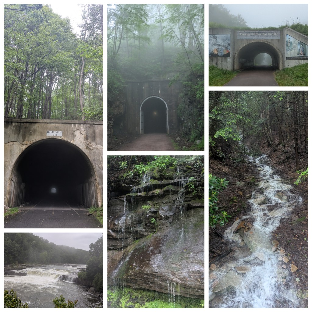
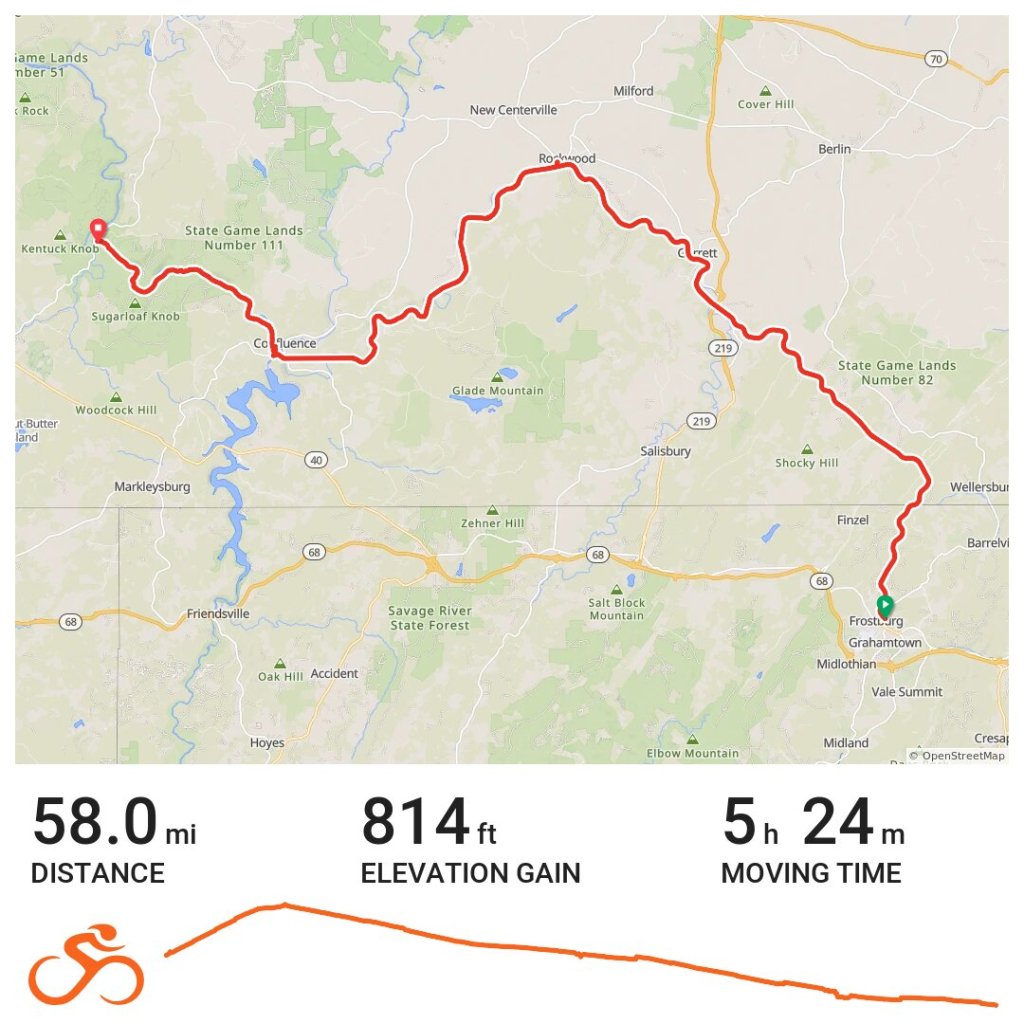
Foggy climb crossing the Mason-Dixon Line up the rest of the hill. Top of the hill is the Eastern Continental Divide and all the water on this side empties into the Gulf of Mexico. It was a long day of tunnels and waterfalls and an afternoon of riding in the rain. Very pretty. Very wet. 🚲 58 miles
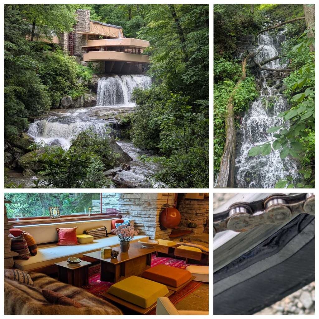
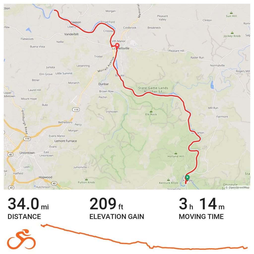
Highlight of the day was obviously my trip to Frank Lloyd Wright’s Fallingwater but then everything started going downhill. I got a flat on my front tire and fixed it, but then after a nice ride through lots of waterfalls I arrived in town and got a flat on my back tire 2 blocks from a bike shop (that was unfortunately closed). Fixed it and started onwards to my original stop for the night before I got another flat and realized that my tire wall had actually busted. I was out of patches and out of tubes and very unsure about my bike making it another ten miles, so back to Connellsville I went since I knew there was a bike shop here. Found a cute B&B for the night and life is good. You never know what’s going to happen on a bike trip and it’s best to roll with the punches. It’ll be a long day of riding tomorrow after the bike shop opens at 11am, but for now I’m going to enjoy the cozy, lazy morning of sleeping in. 🚲 34 miles 
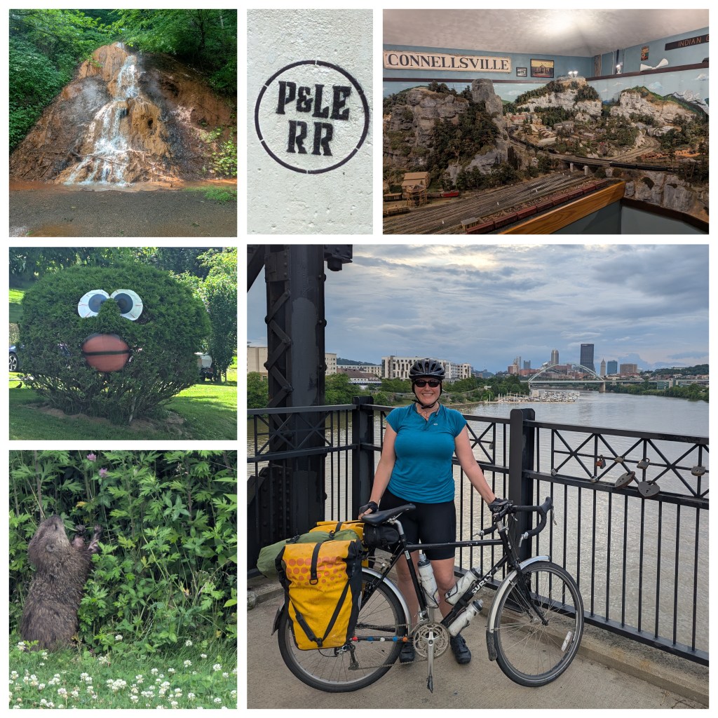
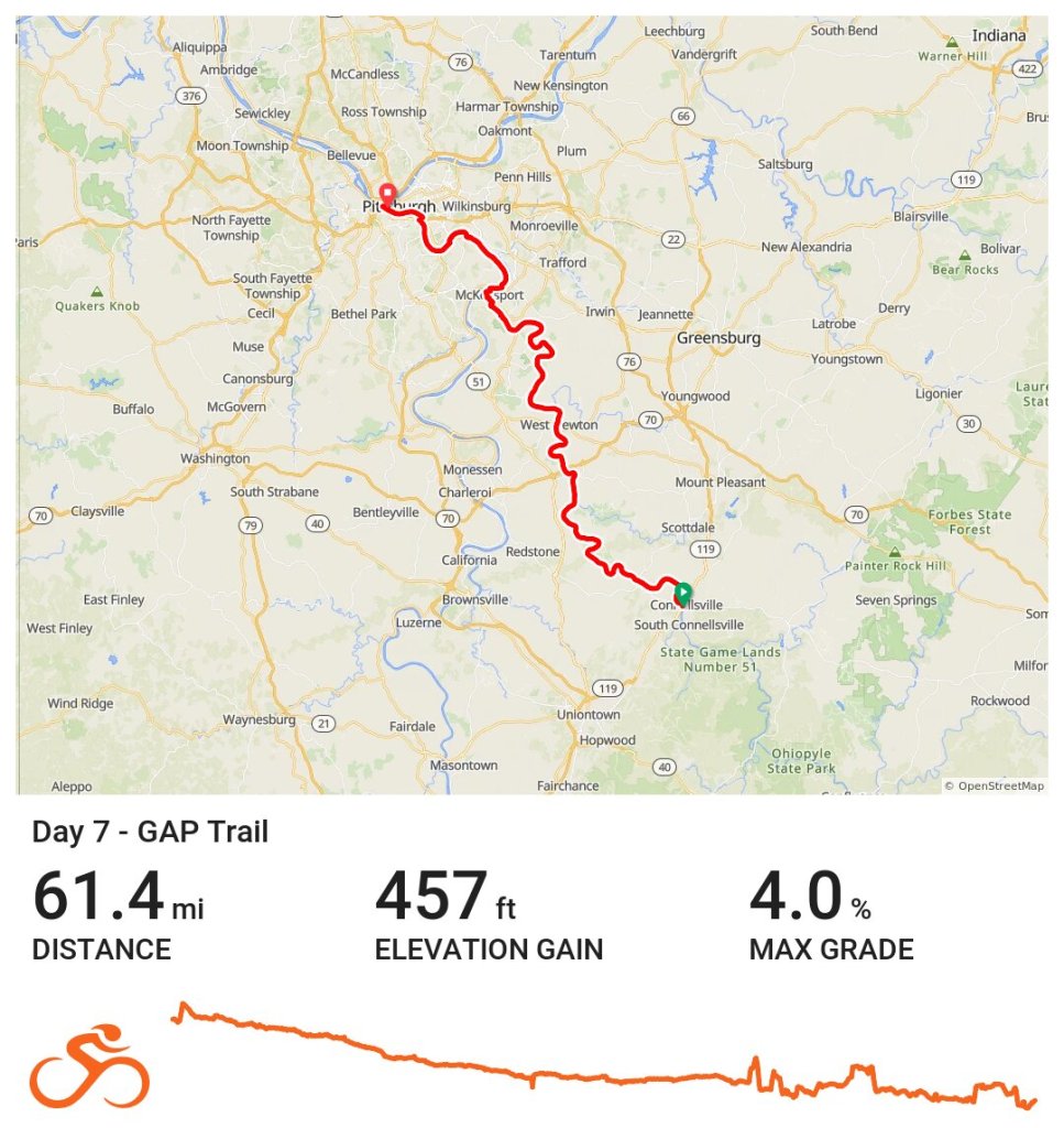
Spent my morning enjoying this working miniature railroad reproduction of the town inside a local canteen. I got a super late start after I bought my new tire and then still ended up with another flat 20 miles out. Got it fixed up and ready to go with the help of another biker and off I went. Plenty of waterfalls, lots of whimsy, and some cute groundhogs. Finally made it to the end of the GAP Trail in Pittsburgh at 8pm! So grateful to be able to do these intense and beautiful rides. 🚲 61 miles 

West Coast Trail

In August 2023, I hiked the West Coast Trail on Vancouver Island. It’s probably my favorite backpacking trail to date and I would do it again in a heartbeat.

So many folks on the trail were surprised when I told them I was doing the trail solo and how that took a lot of courage. But what I think it really takes is trust – trust in yourself and your abilities (both physical and mental) and also trust in other people you meet on the trail. I gained a whole trail family as well as a bunch of bruises and blisters (yellow jackets are evil and so are my boots) but I couldn’t be happier. Forever grateful for this healing journey and thankful to the Huu-ay-aht, Ditidaht and Pacheedaht First Nations who continue to steward this land. 

Carnaval in Mérida & Kayaking in Sisal

Mérida Carnaval

Here’s my last update from my time in the Yucatan. At the end of my stay, my travel plans got pretty convoluted. I decided I wanted to experience Carnaval in Mexico, which led to some backtracking and long bus rides. As a kid, I grew up going to Mardi Gras with my family in Mississippi and Louisiana, but I’ve never seen the festivities outside the United States. There are two big celebrations in the Yucatan, one in Mérida and one in Cozumel. The Mérida festivities are held in an entirely separate part of town in fairgrounds they call the Ciudad Carnaval. I went with Lily, another student from the Spanish school I was attending. We met up in the center of town and hopped on the free women-only shuttle that took us directly there. It’s basically set up like a giant fair with rides for kids, typical street food like churros and elotes, and different stages with performers. The big highlights of Carnaval are the parades and the concerts, but we had some time to kill before they started so we explored the mostly-empty rides.

giant bouncy obstacle course (they let us go through even though we were grown), me and Lily in front of the crazy worm roller coaster, view from the top of the ferris wheel

Finally, it was parade time! The parade went around the outside of this entire “city” and there were bleachers set up for everyone to sit and watch. We, again, scored some seats in the women-only sections which were filled with women and kids. The parade was everything I hoped it would be, with ridiculous costumes, massive floats, and people having a great time.

dancers, special performers, giant floats

The dancers were full of energy and dressed up in brightly colored costumes. Some groups were completely in sync and others were just feeling the vibe.

various dance groups and their costumes

The floats were mostly sponsored by a few different large corporations.

different floats in the parade

One major difference is that not nearly as much swag is thrown to spectators. At Mardi Gras in New Orleans, I came home with bags of beads and toys. Here I managed to catch a few cookies, a couple sets of beads, and a souvenir cup.

frozen strawberries and cream treat, my swag from the parade, headless man costume

The other huge difference is that Carnaval in Mérida holds huge concerts. We didn’t stay for the entire concert, but Matute plays old hits from the 80’s that everyone in the crowd (except us) seemed to know. It was getting pretty late, so we hopped on our free shuttle bus back to the city. Mérida is one of the safest cities in all of North America, which meant we walked back to our hotels without any issues even though it was well past midnight.

Kayaking in Sisal

On one of my last weekends in Mérida, another Spanish student Lucy and I made our way out to Sisal for a kayaking experience. Our guide seated us in the front of his moto-taxi and added a trailer with 2 kayaks in the back and off we went on a long bumpy ride to La Carbonera. The water is very low in the winter months, but we still managed to see a few flamingos hanging out. We kayaked through lots and lots of mangroves and eventually came to an ojo de agua, a natural spring. The water in the ojo is freshwater, bubbling up from an underground source. Back on the main lagoon, the water is brackish because it mixes with saltwater from the ocean. When the rainy season comes, the water gets higher and a lot more flamingos come to feed. On the way back to Sisal, we stopped and went for a swim in the ocean at a beautiful pristine beach.

flamingos, me and Lucy in our kayak next to mangroves, view from swimming in the ojo de agua

Valladolid & Campeche

Valladolid

This town gets overlooked as a destination because most folks see it as the place to stay before and after a trip to Chichén Itzá. However, I thought it was a nice town to hang out in for a couple days even without the allure of the big Mayan ruins close by. In fact, I ended up visiting twice, once on my way to Mérida and once after my three weeks of Spanish school. The town is super walkable, there’s quite a bit of art in town, a cenote to jump in right in the center of town, and the food options were fantastic.

One of the local attractions is the Casa de los Venados, a private house owned by an American couple full of their personal collection of Mexican art. The wife passed away a few years ago, but the husband still lives there. They don’t charge anything for the tour, but take donations that are given to local organizations. There’s a wide variety of art, including a fancy dining room set complete with portraits of famous Mexicans on the back of the chairs and a shaman costume and mask that apparently decorated with real animal blood.

artwork from the Casa de los Venados

Valladolid is home to the former Convent of San Bernardino de Siena, which was home to a Franciscan order of friars. This confused me for a bit, because in contemporary English, convents generally are for nuns. However, apparently back in the day, the word convent was less gender-specific.

The outside of this building has a fun light show that tells the history of Valladolid every night, which includes the city’s role in the Caste War. In New Spain, there was a clear caste system with white Spanish (criollos) at the top, mixed indigenous and European ancestry (mestizo), the descendants of indigenous people who had helped the Spanish to conquer the Yucatan, and then other native groups and African slaves at the bottom. In an earlier post about Mérida, I discussed how the city became super rich from growing henequen. There were henequen haciendas all over the peninsula and the mostly white and mestizo Mexicans were getting rich, while indigenous Mayans were forced off their lands and then made pennies growing and harvesting the henequen for the owners of the estates.

As land continued to be privatized, Mayans organized to prevent their communal land from being taken by outsiders. One of the first events of the war, in 1847, occurred when Mayan soldiers in Valladolid rebelled by sacking and destroying the city. Inside the well located within the convent’s walls, archaeologists have pulled out rifles, bayonets, spears, and a cannon, all dating from the conflict from this time period.

The resistance was actually mostly centralized on the eastern coast of the Yucatan, south of Tulum. They declared themselves as a free state and, for a while, had extensive support of arms and trade from the United Kingdom. Also important to the war effort was the emergence of a Mayan religion that incorporated elements of Christianity and was inspired by a Talking Cross at a cenote. This church (sometimes known as the Cult of the Talking Cross) played a critical role in supporting the resistance. The uprising officially ended in 1901 when the last group of Mayan rebels were defeated.

former Convent of San Bernardino de Siena

courtyard, main church, view upwards of a peace dove from the pulpit (which I found incredibly ironic given the Catholic Church’s involvement in wars and genocides around the world)

One of my favorite places in Valladolid was Xpokek, a small local apiary that gave bee tours. Mayans have always had a close relationship with bees and pre-European contact, native bees were kept inside logs where they built elaborate hives. To harvest the honey, the logs were split open and the bees were moved into a new log. Bees were central to Mayan life and the Mayan god of bees and honey was Ah Muzen Cab (maybe the same upside down god on the Tulum ruins). The native melipona bee is stingless and makes a relatively small amount of honey, only about three pounds of honey per year. In contrast, European honeybees make twenty times as much honey. Melipona honey is rarely eaten and instead is used as a treatment for cataracts and to prevent bacterial treatments in wounds. I also got to eat sikil pak for the first time there, which is a Mayan dip made of pepitas (pumpkin seeds), charred tomatoes, and spices. I’ll definitely be making this after I leave Mexico.

sikil pak, Mayan dancers in the central park in Valladolid, Melipona bee guarding the entrance to their log hive

I did mention the great food, right? Tepache is a kombucha-like fermented drink made out of the rind of pineapples, probably first made by the Nahua of central Mexico. Papadzules are egg stuffed enchiladas covered in a sauce made of ground up pumpkin seeds and a well-loved Yucatecan dish. Tejate is Oaxacan in origin and made from maize, cacao, and the pits of the mamey fruit.

tepache, papadzules, tejate

Campeche

I was struggling in the heat of Mérida, so I took a journey to the western side of the Yucatan peninsula. Mostly I went because I wanted to see the jade mask from Calakmul, but ended up having a lovely weekend in this heavily fortified old city. The walls built by the Spanish still surround the old city, and even though it is located on the Gulf of Mexico, there are no beaches or places for locals to enter the water. However, the malécon along the water’s edge makes for a lovely stroll. Today, Campeche is known for its streets full of colorful houses, which are a joy to wander through.

Back in the day, Campeche was well-known for a type of wood called palo de Campeche, which was used to dye cloth a variety of colors, including brown, purple and orange. This is because it changes color based on its pH. This wood was one of prizes pirates would take from cargo holds when they commandeered ships in the area. Campeche was known as one of the cities where pirates would hang out in between their raids.

view along the malécon, nighttime fountain show, view from the old fort

The old fort is home to a regional museum holding lots of Mayan treasures. Many of the pyramids and ruins in Campeche state have been excavated and brought to this museum. In addition to all of the fancy jade masks, I thought this burial outfit and funeral carpet were exquisitely constructed. The amount of work required to make and sew all of the shells and seeds is unfathomable to me.

collar made of snail shells covered in cinnabar to give the red color, close ups of a funeral carpet made of shells and seeds

When I was in Chile a few years ago I ate a brazo de reina (queen’s arm) which was a sweet dulce de leche filled roll. However, here in the Yucatan, a brazo de reina is a hard boiled egg-filled tamale. The other really fun food speciality in Campeche was a machacado. The bottom of a cup is filled with mashed up fruit of your choice, covered in shaved ice, and then topped with condensed milk, more ice, and a bit of cinnamon. It’s a lot of sugar, but definitely a regional treat adapted for the heat.

Yucatecan brazo de reina, cute llama stamp on napkins, mango machacado

Chichén Itzá & Ek Balam

Chichén Itzá

Chichén Itzá is probably the most famous of all the Mayan ruins in Mexico. It has been extensively rebuilt since its heyday in roughly 700-900 CE. Early in the morning, when I visited, the site is still relatively quiet. There are a few bus loads of tour groups, but the site is large and people disperse rapidly once they’re though the gates. However, by mid-day, this site is busy, busy, busy. Vendors are selling souvenirs on every path and tourists are huddled in circles around guides listening to stories.

Even with all the commotion, Chichén Itzá is stunning. The work they have done to restore the ruins gives a clear impression of the power that this city-state used to possess. From the menacing platform of skulls to the giant pok-ta-pok playing field to the pyramid centerpiece, the elites of this city used strength and authority to control their subjects.

Pok-ta-pok features prominently at almost every Mayan ruin I visited. On signs, it’s often just called el juego de pelota, the ball game, in modern Spanish. The goal is to score points by getting a rubber ball (between 5-10 lbs) through a hoop positioned higher up on the sides of the playing court. There were two teams and players were not allowed to touch the ball with their hands or feet. They wore extensive gear to protect themselves and there are frequent mentions of bruised and injured players.

feathered serpent (kukulkan) head decorating the pok-ta-pok field, El Castillo also known as the Temple of Kukulkan, pok-ta-pok goal high up on the side of the wall

In Mérida, there’s a contemporary pok-ta-pok match every weekend across from the catherdral. I didn’t get there early enough to get good videos, but you can watch various YouTube videos of the sport. It looks a lot like hacky sack with a lot of sliding. The reason this sport is so important to Mayan culture is because it is a part of the Popol Vuh, the Mayan text that includes the story of creation. There are three sets of twins in the story, and the second set, Hun-Hunahpú and Vucub-Hanahpú, are invited to Xibalba to play in a pok-ta-pok match. They are defeated by the lords of the underworld and sentenced to death. Hun-Hunahpú’s skull is placed in a tree that produces gourds.

A woman named Xquic notices one of the gourds is in the shape of a skull, and when she goes to touch it, the skull spits on her hand and she become pregnant with Hun-Hunahpú’s twin sons. She leaves Xibalba to visit her mother-in-law who does not believe her since her sons are dead. However, she passes a test involving maize and then everyone believes her that she indeed is pregnant with this dead guy’s kids. Eventually the twin sons are born, they grow up, and return to the underworld to avenge the death of their father and uncle. They then become the sun and the moon and humans are then created from maize.

The Tzompantli was a large platform used for displaying skulls, most likely of sacrificed victims and prisoners of war. This one is located next to the pok-ta-pok field and some think that the losers of the game would be beheaded and their skulls would have been placed there. According to those interpretations, if you died during a game of pok-ta-pok, you skipped going to the underworld of Xibalba and headed straight to heaven. Because of this, others think that the winners were decapitated as a reward.

close-up of skull carving, side view of Tzompantli, Temple of the Bearded Man (named because of the carving of a bearded man)

This archeological site is huge and there are buildings still being uncovered. The Group of the Thousand Columns is a bunch of columns lined up in a grid like manner. On some of these columns, it’s easy to see carvings of warriors that would have been painted in striking colors. The whole area would’ve been covered with a roof and would’ve formed a type of passageway out of the heat of the sun. There are also at least two cenotes. The Sacred Cenote was used to dump bodies after human sacrifices and the other one was probably used as a water source for the city.

tiered building corner, Sacred Cenote, Group of the Thousand Columns

My other favorite buildings were at the end of the tour. The House of the Nuns was probably a house for Mayan royalty and its carvings are still easily visible today. El Caracol was a Mayan observatory used for tracking astronomical events. All observatories seem to be called el caracol, the Spanish word for snail, because of how the top of the building resembles a snail shell. (The tiny observatory I saw on Cozumel was also called El Caracol.)

close-up of carvings, House of the Nuns, El Caracol

Ek Balam

Apparently on a clear day, it’s possible to see Chichén Itzá from the top of the Acropolis in Ek Balam since they’re less than 40 miles away from each other. The biggest structure is the Acropolis, which is a mixture of a very tall and steep pyramid combined with a rectangular building with lots and lots of rooms. The Acropolis contains the tomb of Ukit Kan Lek Tokʼ, who was once the ruler of the town. His tomb has an awesome stucco facade with another earth monster mouth guarding the entrance.

Acropolis (the tomb is under the thatched roof on the top left), view from the very top

glyphs at bottom of Acropolis, tomb opening with monster mouth, close-up of carvings

The site itself is pretty small, with an extensive set of walls encircling the city. There are four sets of walls around the city and the last one seemed have been hastily built, probably as a last ditch effort to protect the city against an invading attack.

me posing with the entry gate, two buildings called the twins, view of the thick outside wall

black spiny-tailed iguana, ceiba tree (central to Mayan spiritual beliefs in that it connects the underworld, the middle world, and the heavens), a steam bath

Cenote Xcanche

A short, bumpy bike ride away from the Ek Balam site, is this lovely cenote (bikes included as part of entry costs). This is an open-air cenote with awesome vegetation and a few catfish swimming around.

view of cenote walls plant roots underwater, pale catfish

Mérida

I stayed in Mérida for three weeks, taking Spanish classes and wandering around the city. The colonial influence is strong here and old money still has a deep hold on the community. In Mexican slang, the word fresa (literally strawberry), refers to spoiled, young people with a lot of privilege and parts of this city definitely have fresa vibes. At one time, the Yucatan was the one of the richest states and Mérida was one of the richest cities in Mexico thanks to the henequen industry, which, of course, I’d never heard of until I got here. Henequen is made from a type of agave (different species than the one used to make tequila), that was twisted into ropes, cords and fabric. People made a lot of money from the plant and their ruthless exploitation of workers. There’s actually a sizeable Korean population in Mérida because of this industry. Originally, a bunch of Koreans signed on to work 5-year contracts on henequen plantations, but earned almost nothing, were frequently beaten, and often didn’t even make enough money to return home. So they stayed and their descendants still live here.

Architecture

Because of the old money in this city, there’s a lot of European style architecture in the rich enclaves of town. Just outside the city center, the architecture switches to square cement houses built right next to each other, forming one contiguous wall on each block, interrupted by fancy windows and doors.

City Center: Palacio de Gobierno, Pasaje Revolución, fancy corner house (by the way, all street corners have this diagonal cutout)

Paseo Montejo: El Minaret, Monumento a La Patria, El Palacio Cantón (home to the Regional Anthropology Museum)

Mérida in Lights: Catedral de San Ildefonso, neon boba sign, old penitentiary lit up with Mayan calendar glyphs

Art

Mérida is definitely a city of museums and lots and lots of art. Every day after school was finished, I would try to get to another museum or gallery.

top (l to r): embroidery depicting typical Yucatecan scenes from the Gran Museo del Mundo Maya
bottom (l to r): sculpture in MACAY (Contemporary Art Museum), painting from MACAY, painting in the Palacio Gobierno by Fernando Castro Pacheco

Food

Of course, tacos are available on every other street corner, but the Yucatan has some special regional dishes. Salbutes are basically tacos, but have a puffier base than a regular tortilla. Panuchos are similar to salbutes, but are filled with beans and then fried a bit. There’s some differences in the toppings, but I’m vegetarian, so those subtleties were lost on me. Chaya, the tree spinach I briefly mentioned in an earlier post, gets tossed into a lot of dishes.

Onto the desserts: marquesitas are crepes filled with your choice of sweet toppings (nutella, cajeta (caramelized goat milk), or cream cheese), a bit of fruit (bananas and strawberries are common), and then topped with lots and lots of cheese before being rolled up into an easily portable street treat. Champola is also a speciality of Mérida in particular. It’s simple a sorbet covered in milk, but not blended together. The best flavors are guava, coconut, and mamey (a fruit with a bright orange flesh that I’ve only had while traveling, but apparently does grow in Florida and Hawai’i).

Mayan styled salbutes (with chaya and pepita seeds), vegan tacos de birria (not Yucatecan, but these were amazing), marquesita with nutella and banana

gorditas (stuffed with cheese and beans and mushrooms), coconut champola, panuchos with eggs

More Mayan Ruins

Balamkú

My guidebook mentioned that Balamkú was near Calakmul and was definitely worth a stop because of an enormous frieze that is actually open to the public. Now, I love art, but there’s a lot of art vocabulary that still baffles me and for some reason, I thought it would be a giant painted mural, maybe with a little bit of texture. I definitely wasn’t prepared for the size or scale of this piece of work. A nice guardian let me into the locked room and proceeded to share with me all of the animals carved into the giant stucco wall. There are four tall sections which are composed of a king on top, an amphibian in the middle, and the “monstruo de la tierra” (Earth monster) at the bottom. In between these four kings are kneeling jaguars. The whole scene represents entering the underworld for whatever rituals needed to be conducted there. Click on the images if you want bigger photos.

tall king section of frieze, jaguar (look for the claws), frieze and me (for scale)

pyramid view, decorative archway, and trees growing through steps on the main plaza

Within a short drive of Balamkú, the Zotz Cave puts on a nightly show with over 3 million bats leaving the cave to go in search of their dinner. There’s only room for about 20 people to watch from a path overlooking the cave. Right around sunset, the bats start to emerge. Eventually, it looks like a giant bat volcano and there are so many that the bats sometimes collide with the humans that are standing around. One bat attached to my shirt and another one landed in my hair. They both safely detached and went on their way. There are between 7-10 different species of bats that live in the cave and most of them join this nightly insect feast.

Chicanná

This site doesn’t have giant pyramids, but instead is a small town filled with intricate carvings and decorations. Chicanná got its name from one building in particular – the House of the Serpent Mouth. Chi means “mouth,” can means “serpent,” and na means “house” (thank you, Wikipedia). This building is still incredibly well-preserved, but when it was built around 750CE, it would have covered in a layer of stucco and been painted in vivid colors including red and green. This elaborate carving probably represents the monster of the underworld. No one knows exactly how this building was used, but one idea is that rituals were conducted here and this door representing a symbolic portal between the middle world (where humans reside) and the underworld.

House of the Serpent Mouth

Because of the huge number of decorations, archeologists think this was a town for elites where some rituals would’ve been conducted. It’s situated very close to Becán and probably functioned as a rich suburban enclave.

close-up of carvings

Becán

Becán is a big city with a giant pyramid. Due to some complicated rental car logistics, I only had about an hour to run around and climb up these awesome ruins. I definitely wished I’d budgeted some more time for this sprawling site. This city was surrounded by a giant moat, which probably functioned to both protect the city, as well as to serve as a supply of water for the town itself. It served as regional capital for the surrounding countryside where goods were brought and distributed to other locations.

biggest pyramid in Becán (Structure IX), view from the top of the pyramid down onto another ruins (Structure VIII)

One of the most interesting parts of Becán was how much housing has been uncovered and is open to tourists to enter. The rooms are relatively small, but most of them have some kind of built-in bench or bed. The Mayan arch is a a set of parallel walls that at some point is angled inwards and is then covered with a single layer of wide bricks at the very top. This approach to construction appears frequently in Río Bec architecture, the style associated with Becán, Chicanná, and Xpujil.

really thick tunnel wall with a Mayan arch, view from the top of one of the ruins, typically Mayan bedroom with Mayan arch above

Xpujil

This is a relatively small site, located close to Xpujil (pronounced eesh-poo-heel) town which is why it gets a lot of visitors. Río Bec architecture frequently includes rounded corners, temples with two towers (although this one has three), and monster mouth doorways. My photos of the large temple with three towers didn’t come out to well with the shadows from the afternoon sun.

carvings, close up of one of the temples three towers with clear layers, tree growing on top of the ruins

If you made it this far, here’s a bonus video of spider monkeys playing around in Balamkú.

Calakmul

Ancient Mayan City

Despite being one of the largest and most powerful Mayan city states, Calakmul has never gotten the same attention as Chichen Itza to the north and Tikal to the south. It does have UNESCO World Heritage status, but I’d never even heard about it until I started looking through my guidebook. Right now, the public transportation options are limited and there aren’t many group tours, so it’s challenging to get to. I chose to rent a car in Bacalar and drive many hours on pothole-filled roads. However, everything is changing: the Tren Maya is currently being built (all the heavy trucks contribute to the pothole problem) and will probably be done in the next year. This area will soon be inundated with tourists. The tiny 20-car parking lot is being expanded; the roads are being widened and repaired. Tourism and its impact on the area is about to explode.

Because I knew almost nothing about Mayan history and culture, I hired a guide for this tour and we met at 4:30 in the morning so that we could arrive in the park right when it opened. There were only a couple other people wandering around at that time and it is truly surreal to try and imagine the hustle and bustle of a once-thriving capital city when almost no one is around. The view from the top of the king’s pyramid (Structure II) is incredible: a clear view of miles and miles of trees. But 1500 years ago, there would have been settlements and roads in every direction. Even though the large structures of Calakmul have been excavated, the foundations of the old city remain buried beneath the trees.

from the top of Structure II, the home of the former kings of Calakmul and one of the tallest Mayan pyramids

The king’s palace actually has two levels and it is impossible to see the place where I’m sitting from the ground. The king’s quarters on top would’ve been relatively hidden from the common folks down below. He also would’ve had an elongated head because all of the elite Mayans had their heads tightly bound as children. Everyone in the elite class actually looked completely different from the rest of the people. Mayans also engaged in face scarification and wore a lot of heavy jewelry, especially in their ears.

view of the king’s palace from the bottom, a close up of one of the stelas that depicts a ruler standing on top of a slave who is kneeling

Stelae were often constructed to commemorate people and events. Many of the stelae at Calakmul are in bad shape. There are a few different ways to write in Mayan language: one way uses pictures to depict a specific meaning, another uses pictures to match the syllables of the word, and a third combines both of these together. Despite the complexities, experts can generally decipher most Mayan script today.

top part of stela showing the ruler standing above the slave, view of 5 stelae from the top of Structure I (pyramid that was probably used as a temple)

The pictures below show another large pyramid (Structure VI) where astronomical sightings were made. This building and others were built so that the sun would line up in specific places on the solstices and on the equinox. Some of the engravings on the sides of the stelae are still very clear even after all this time. Although the front and back of these stelae were removed by looters, the sides discuss the people involved as well as the dates of events.

view from bottom of the pyramid, view from top of the other two large pyramids, engravings on side of a stela

So far, at least four tombs have been found inside the king’s pyramid and even more tombs were found in other structures. Even houses of common folk have skeletons buried inside of them. The bodies of the elite class were buried with elaborate outfits and offerings to the gods.

Many graves not only have masks made of jade, but also necklaces, ear plugs, and other fancy adornments. There is no jade in Mexico, so all of this jade was most likely imported from what is now Guatemala, which shows the extent of trade in the region. All of these jade funerary masks below were found in Calakmul, but were removed and put into museums in the city of Campeche. (Side note: this is actually one of the reasons it took me so long to write about this, because I had to go to Campeche to see these masks.) The mask in the top right is the most elaborate and probably belonged to Yuknoom Yichʼaak Kʼahkʼ, the ruler of the Mayan snake kingdom starting around 650 CE.

top row (l to r): mask of Yuknoom Yichʼaak Kʼahkʼ, jade mask & ear plugs with cinnabar used on the mouth, another intricate mask depicting a few different animals
bottom row (l to r): a mask representing Yuknoom Ch’een II (the father of Yuknoom Yichʼaak Kʼahkʼ), another jade mask & ear plugs, jade mask probably for a priest with a second set of eyes representing his supernatural vision and the red lines on his cheek showing ritual scars

Calakmul Biosphere Reserve

After our tour of the ancient city, my guide took me on a short walk through the nearby protected natural area. Even wearing insect repellant, a swarm of mosquitos kept threatening to attack my face. There’s so much to see in the rainforest, but my guide started by showing me the chewing gum (chicle) tree. By cutting diagonal lines in the trunk, they were able to get the natural resin to flow and that was harvested and exported to make chewing gum. I also was introduced to the Mayan breadnut (ramón) tree which is used to make bread or a type of porridge. We came across a swamp and I could see a crocodile hanging out on a log. Perhaps the most exciting thing I saw was on our slow drive (avoiding potholes) back to the entrance, when a tayra crossed the road. I didn’t get a photo of it (but Wikipedia has some) and my guide said it was only the third time he’d ever seen one. Folks here call them the viejo de monte (old man of the mountain) because of their white heads.

top (l to r): chicle tree with scars, natural chewing gum, Maya breadfruit tree starting to grow from seed
bottom (l to r): papaya tree, Central American Gulf Coast toad, termite nest with holes most likely made by parrots that are living inside of it

Riviera Maya – Part 2

Playa del Carmen

Playa, as it is affectionately called locally, is a strange little oceanside town. It’s got an entire avenue (Quinta Avenida) dedicated to hawking souvenirs, tours, tequila, and sunscreen. “Mexican Disney” is how I described it to a friend. I get the appeal. There are nice beaches, lots of fresh and tasty food, and an entire English-speaking industry devoted to serving tourist needs. I understand why expats and digital nomads would decide to settle there. However, as an independent traveler type who is more excited about sea life than wave life and is looking for a bit more authenticity, I can’t really recommend the city.

view of sandy beach,

Beach 72 in Playa Del Carmen, famous Portal Maya sculpture, and a liter of passion fruit (maracuya) juice

Tulum

Word on the street is that Tulum was a lovely little town about 10-20 years ago and now has turned into the tourist destination du jour. I didn’t even go to the beach part of the town, but I did make it the Mayan ruins that gave the city its name. Probably called Zama (meaning sunrise/dawn) by the original builders, during the colonial era it got the name Tulum (meaning wall). As the city of Chitzen Itza declined in importance, Tulum came to prominence. The city has incredibly thick walls (16-26 ft deep) that surround three sides of the city and the last side faces the ocean. Tulum was well-protected because it most likely functioned as the port city for Coba with large ocean-going canoes making regular visits. Flint, ceramics, gold, salt, textiles, jade and obsidian were most likely being imported, while feathers and copper were being exported. Obsidian came from central Mexico, jade from Guatemala, copper from Honduras, and cacao beans from the Tabasco. There is also evidence of the city’s worship of the Descending God (or Diving God), seen in the photo of the temple below. This god is always pictured head-down, feet-up and may be the same as Ah Muzen Cab, the Mayan god of bees and honey.

top row (l to r): Black spiny-tailed iguana, House of Chultun, Temple of the Wind
bottom row (l to r): Temple of the Descending God, Temple of Frescoes (close up of corner carving), Dancing Platform

The entire Yucatan peninsula is dotted with cenotes, natural holes made from limestone collapsing. Cenote Yaxmulito was the first one I got to swim in, and I had it all to myself for the first 15 minutes I was there. This one was almost entirely enclosed with just a few holes allowing a bit of light in. I have to say, it is utterly surreal to swim amongst stalagmites in the dark.

Views of Cenote Yaxmulito

On the day I arrived at my hostel, there were large banners celebrating the anniversary of a local musical school. I didn’t think much about it, but that evening, there was a lovely neighborhood gathering to watch not only young performers, but also a few professionals do their thing. It’s such a gift to just wander into local events and meld into a crowd. Other kids came around and handed out streamers for us to wave in support. I took a video because the music is a bit different than I expected to hear.

Bacalar

The Laguna de Bacalar is one of only a few places in the world where stromatolites are still being formed. Stromatolites are natural structures built over time by cyanobacteria and are some of the oldest fossils we have. When I was biking across New York last fall, the fossil stromatolite I took home from the Herkimer mine was probably about 900 million years old. Of course, I got in a kayak and paddled myself around until I found some. Mostly, I just came to hang out and swim in this incredibly peaceful freshwater lake. It’s quite a ways off the beaten path, but was a nice layover en route to my next destination.

living stromatolites, view from the hotel, fossil stromatolite from Herkimer, New York

More photos of delicious food I’m eating:

mangos with chamoy, delicious vegetarian sopes across the street from the Tulum ruins, agua de piña y chaya (pineapple and chaya, which is also known as tree spinach)

Riviera Maya – Part 1

It’s been awhile since I’ve written much here, but I’m back on the road. I tend to appreciate these reflections later on, so I’m going to try to write some more this year. I’m spending a month on the Yucatan Peninsula and I’m definitely stuck in the tourist circuit right now. There’s benefits to this, of course: good wifi, plenty of food options, safe pedestrian walkways, beautiful sights, etc. But there are also the downsides: never-ending asks on the street to drink tequila, go scuba diving, take a ferry; the endless hustle-bustle of noisy tourists; and a bit of price gouging. It’s all part of traveling, but I haven’t lived the backpacker life for a while, so I can feel my body and mind adjusting to life on the road again. This part of the trip was really about getting in the water and seeing cool marine life, so it’s mostly just photos of awesome underwater animals.

Puerto Morelos

All the guidebooks describe this as a sleepy, fishing town and that’s probably why I enjoyed it so much. The section of town near the ocean is tiny and can be walked from end to end in about an hour. It’s also right on the Mesoamerican Barrier Reef (the second largest barrier reef in the world) and I could snorkel right from the shore.

notable landmarks in Puerto Morales include Faro Inclinado (the leaning lighthouse), the fancy colored sign, and this lovely disheveled pier

Here are some highlights from a day of shore snorkeling and one boat trip to Parque Nacional Arrecife de Puerto Morelos (Puerto Morelos Reef National Park).

stoplight parrotfish, scattered pore rope sponge, rock beauty

Atlantic peacock flounder, brain coral, smooth trunkfish (this has to be one of my favorite fishes)

giant anemone, spaghetti worm, purple sea fans

Cozumel

One taxi ride and one ferry ride later, I was on the lovely island of Cozumel. I came for the snorkeling, but there’s also a really lovely bike loop that I wanted to ride. The loop is only 40 miles, but I added a 10 mile out-and-back trip to Punta Sur, the very bottom of the island.

the beach on the wild side (the east side) of the island, view from the top of the Punta Sur lighthouse, lovely palm tree

The rental bicycle wasn’t quite the right size, but the cyclopista is almost completely flat and is well-maintained. Punta Sur is a nature reserve and although one side is on the ocean, the other side is a brackish mangrove lagoon, which is home to several American alligators. I wasn’t sure if I should go, but I met some American bicyclists in the Rasta Bar and they convinced me my tires would be okay on the pothole-filled dirt road, so off I went.

black spiny-tailed iguana on the cyclopista, me next to Faro Celarain (lighthouse in Punta Sur), an American alligator in the nearby lagoon

There used to be a very nice reef on the ocean side of Punta Sur, but it has clearly seen better days. It took me awhile to realize that a buoy way offshore was the marker for the start of the old reef. Once I figured that out, I found a lot more underwater life.

snorkeling in Punta Sur: red cushion sea star (not red, definitely orange), queen conch (zoom in and you can see its eyes), Guilding’s sea star

I also took a boat tour out to El Cielo and the reefs we went to before it were just teeming with ctenophores. These comb jellies are incredibly difficult to photograph and all of the ones I saw were iridescent (not bioluminescent), but I only got clear colors in one photo.

ctenophore, yellow stingray, another ctenophore

netted barrel sponge (these are huge!), another red cushion sea star (definitely not red), and a brown encrusting octopus sponge (what a great name)

While snorkeling around at the Money Bar, I found this brassy drummer defending what seemed to be its territory (a float in the water). It was aggressively fighting off any fish that came near and was showing the black and white dotted pattern. It eventually swam away and slowly lost its coloration, turning back into a shiny fish. I’ve never seen anything like it and now I want to know everything about how fish skin changes colors. I’ve taught about cephalopods and chromatophores for years but I had no idea that fish could do the same thing.

brassy drummer (in various stages of coloration)

And here’s the food update section since folks ask what I’m eating. Honestly this whole section of Mexico is very vegan / vegetarian friendly. There’s even raw food places in almost every town. I’m really enjoying the fresh fruit juices for 30 pesos (less than $2/liter).

chilaquiles and fresh juice in Cozumel, view from the Rasta Bar on Cozumel, delicious vegan tacos from Veggie Veggie Street Food in Puerto Morelos